Friday, March 31, 2017

There's Plenty of Storm Left

Even though dedicated snow day hounds were disappointed by the outcomes this morning, this storm has some bite of its own left in it.

Let's just say this storm isn't moisture starved. The wall of wetness is still headed our way as the low pressure system begins to intensify all the way down there around the Delmarva peninsula.

A lot of moisture yet to come. 12:45 PM radar.
The Berkshires are in the Winter Weather Advisory period, and we have an outside chance of getting upgraded to a Winter Storm Warning later this afternoon or tonight if the temps drop a degree or two. Your elevation also will determine the severity of your weather this afternoon and evening. Places above 1500 feet will get a combo of snow and sleet while locations below 1500 feet will see wet snow and rain with the eventual changeover to all snow for everyone.

Driving conditions tonight don't look encouraging. The messiness should extend into Saturday morning as well.

Enjoy the weekend, and let's hope this is winter's last gasp.

Late March Storm Update & Cancellations

At the GSD Home Office, we have a light coating of snow on the ground but roads are just fine. Heavy snow bands are in our very near future--between 6 and 8 AM--which will make the commute to school interesting.

Right now the storm is not tightly organized, but snow, sleet, and rain should become steadier throughout the day as a secondary low forms off the coast.

The 6 AM radar.
We do have a few cancellations and early releases to report. We'll add to this list if/when more come in, and we do think a few more will add their names to the release list. New schools to the list will be in blue.

TWO-HOUR DELAY:

Southern Berkshire

SNOW DAY:

Emma Miller
Gabriel Abbott Memorial
Mohawk Trail

EARLY RELEASE:

Greenfield
Southwest VT Supervisory Union
Stamford, VT

Thursday, March 30, 2017

April Fool's Storm -- The Evening Report

It's almost April and we're sweating out another snow day decision. Thank you, winter of 2016-17, for making up for last year.

Here are a few maps before we talk about tomorrow:

Channel 6 Albany

Channel 10 Albany
National Weather Service Albany

Really, it's just mess. The latest models are definitely leaning toward longer periods of sleet and freezing rain, which they were not indicating earlier in the week. The predicted temperature is still a moving target--some models show warmer and others have the cold air in place longer. This is just to say that we could see 1 inch or we could see 10 inches. Elevation and north/south location will make a big difference tomorrow.

Despite the uncertainty, this is what the GSD Staff thinks is going to happen. It will be snowing or sleeting during decision time for Superintendents tomorrow morning, especially north of I-90. Most will choose to go with a full school day because the roads won't be too bad. Because of the threat for ice and power outages, one or two will get nervous and opt for the snow day. The likely candidates are North County schools as well as Central Berkshire, due to the higher elevation. Then, if we get an extended period of sleet and freezing rain, we could see some schools call the early release and let the youngsters get a head start on their weekend. Schools south of I-90 are probably going to have a full day, with a slight chance of a delay.

The Staff will be up early. We'll update on the storm and run a list, should schools opt out tomorrow.

Winter Weather Advisory for Northern Berkshire

The NWS has just changed the Winter Storm Watch to a Winter Weather Advisory. Under normal circumstances we would consider this a downgrade and our chance for a snow day would also be downgraded, but nothing about this storm is typical.

The forecast now is for 4-7 inches of snow but--as we feared might happen earlier in the day--the storm is now scheduled to start a few hours earlier. The Winter Weather Advisory begins at 2 AM, which means it could be snowing and/or sleeting right in the wheelhouse hours of 4-5 AM.

A slight upgrade from earlier in the day. Image courtesy of the NWS.
So...we're going to alter the True North Confidence Meter only slightly. North County schools have a better chance for a snow day now due to the improved timing, but not by that much. South County schools still look like they'll be left out as the snow fall total likely won't be high enough to warrant snow days.

Looks about right. Thanks to WNYT Channel 13 for this image.
Because of the very long time period of this system--all the way through Saturday afternoon--it doesn't seem as if it will be snowing hard enough in a short enough period of time to make the roads supes dangerous. But that's merely speculation on our part as this storm is proving to be very hard to nail down even 12 hours in advance of it.

We'll be out of commission for a few hours this evening, but we will be back around 9 PM for our final update of the day.

Don't Let It Fool You

For ease of use, we'll call this the April Fool's Day storm. And it does appear to have some trickery up its sleeve.

More signs are pointing toward a full school day or an early release tomorrow for the northern half of Berkshire County. We've had no movement on the Watch to a Warning, and Advisories have not yet been posted for South County. That could all change this afternoon and evening, though, so don't set anything in stone just yet.

A bold call from The Weather Channel.
The latest run of the models indicates the brunt of the storm will hit just to our north, northwest, and east. The Weather Channel's map appears to be very aggressive, calling for over a foot for our neighbors in Franklin and Hampshire County. We'll be surprised if we see totals that high.

But just the fact that there's such widespread difference in the predicted snow fall totals means that we can't sleep on this storm. Given the winter we've had, it would not be wise to underestimate this storm's potential. The moisture will be there. It all comes down to how long it stays as snow.

One of our favorite maps: the NOAA Probabilistic Snowfall Map.

The GSD Staff unanimously agrees that school will be in session tomorrow. If this were the first storm of the season, we would probably see full snow days because of (1) the novelty of it and (2) there's house money to play with when you haven't used up any snow days yet. But because the end of the school year is hastily approaching July 1, Supers will be quick to pump the brakes on a snow day for tomorrow. The early release, however, is very much in play for North Berkshire schools as conditions should deteriorate as the day progresses...as long as it stays all snow.

The big stumbling block for our staff is the temperature. We will get close to 32 degrees tonight but not beneath it. Snow can still fall when the temperature is above freezing, but often it takes a while to stick to the roads in those situations. Roads should be passable tomorrow morning unless the storm suddenly speeds up and the snow starts falling around 4 AM instead of 6 AM. We'll have to wait until later to know exactly when the snow should start to fall.

We stay informed to keep you informed!

April Fool's Eve Snow Storm -- Morning Report

We have a few tidbits for you this morning as you prepare for snow day 7, 8 or 9 for your school.

*The timing of the storm is now not as good as we thought it would be a few days ago. It's still very good, but it looks like the snow will start for the Berkshires between 6 and 7 AM. So, this means Superintendents are going to have to make their decision based on the forecasted snow and anticipated driving conditions, which is never an ideal scenario.

*It will snow and sleet throughout the day for Northern Berkshire county, but we'll see a changeover to rain south of I-90. Higher elevation towns will see snow all day with a lesser chance of sleet mixing in.

*Snow-to-liquid ratios will be low for this storm. The snow will be a nightmare to shovel if it accumulates over 6 inches.

*The period of heaviest snow is expected to be in the early evening on Friday. Snow will last until the earliest hours of Saturday.

Right now we think snow days and early releases are in play. Delays seem unlikely given the 6 AM start to the storm. We could see some schools making the call to go with an early release tomorrow morning as the morning drive will likely not be as bad as it potentially could be in the afternoon.

The words we are consistently seeing from our weather sources are "low confidence." There are so many moving parts--the timing, the intensity of the late March sun, the rates of expected precipitation--that it will be hard to predict the final outcome. The warm late March sun makes a changeover likely, but if the precipitation comes down hard enough, that will pull cool air in and prolong our period of snow tomorrow and tomorrow night.

You can see why this will have to be a "game day decision." No Superintendent will make his or her call tonight--of that you can be assured.

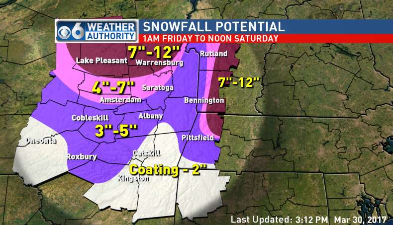
We do have a few maps to share, with more to come later.

From NBC Channel 22 in Springfield. 
From the National Weather Service in Albany.
Of course we'll have much more later today as we start to see a few more runs of the models.

Wednesday, March 29, 2017

Winter Storm Watch for Friday for Northern Berkshire County

We don't suggest you go into full freak out mode just yet, but the National Weather Service just dropped a Winter Storm Watch on Northern Berkshire County. Nothing has been posted for Southern Berkshire County yet, but we see a Winter Weather Advisory in your near future.

The Watch is up because the potential for 5-10 inches of snow exists. Because Northern Berkshire is the southernmost area of the watch, this likely means that we'll be on the low end of the 5-10 inch prediction. Also, the Watch begins at 5 AM and ends at 11 AM on Saturday.

We do want to remind you that a Watch does not mean a snow storm will definitely happen. We will raise the True North Confidence Meter up a few ticks in response to the Watch, but things will get real only if the Watch gets bumped up to a Winter Storm Warning. If that happens, students in several schools will not have classes on Friday.

Perhaps it's a sign--perhaps it isn't--but 20 years ago on these exact dates New England got pounded by a major snow storm. Here's a map from the 1997 storm on March 31 and April 1, courtesy of Boston meteorologist David Epstein.


We really doubt we'll reach snow totals that high, but it is a nor'easter and there may just be enough cold air in place to give us moderate to heavy snowfall throughout the day on Friday.

Twelfth graders--and sixth graders--rejoice.

Snow For Friday

Just when it seemed we had turned the corner--whammo!--winter is back. Or so we think.

According to our sources of information, it looks like snow will fall in the Berkshires starting late on Thursday night. Yes, the morning commute could be impacted.

As of this morning, we're seeing a wide range of possibilities for snow outcomes. At the low end, we would see a coating of heavy wet, slushy snow in lower elevations with a transition to rain by midmorning. In higher elevations, the snow would hold on for longer, leading to 2-4 inch snow totals, before the rain kicks in in the afternoon. Given this outlook, we might have a delay or two in the usual locations (Florida, Central Berkshire, Southern Berkshire).

From the NWS--not too bad so far. But this map will be updated.
On the high end, we could see 4-6 inches in the lower elevations and 8-12 in the hill towns. Given this outlook, we would see--[deep sigh]--cancellations.

Those of you who want to get on with spring, take comfort that there are many moving parts with this storm and it could all turn to rain. Keep those fingers crossed.

Those of you who want a snow day--pretty much 12th graders and that's it--you've been on a hot streak this winter, so why won't that continue?

The GSD Staff is at the ready; we'll have much more later today.


Sunday, March 26, 2017

Freezing Rain for Sunday Night

If you're out and about tonight (Sunday), be aware of the potential for freezing rain. We won't see steady rain tonight, but a few showers could slide through the Berkshires and create the potential for slightly hazardous driving conditions.

We know what some of you are thinking, and we need to squelch those ideas right now. There's no chance for the freezing rain to impact the commute to school tomorrow morning. As the rain moves through, temps will be on the rise. We may even hit 60 by Tuesday.

With daytime temperatures in the 40s and 50s all week, we could be seeing the end of winter. Expect rain on Monday and Tuesday and then dry days for Wednesday and Thursday. Friday is up in the air, as the professional weather prognosticators have forecasted a rain/snow mix.

Spring sports teams hoping to get on fields this week will likely have to wait another week due to all the rain, but the snow should be all gone by Wednesday.

We'll be back later in the week to look at Friday's storm. We'll know more as the storm gets closer to us.

Thursday, March 23, 2017

Winter Weather Advisory for Friday

Old Man Winter still refuses to give up the ghost.

The old feller is relentless. While we don't think the forecast will impact the length of the school day on Friday, everyone should know that we could see some messy weather in the morning in the Berkshires tomorrow. We have been issued a Winter Weather Advisory by the National Weather Service.

Expect to see snow and sleet starting between 7 and 8 AM on Friday. The ride to school could be dicey--especially for the elementary school set--but the late (relatively) arrival of the snow will mean delays are highly unlikely. The ground could get coated quickly with the cold temperature in place. We might see an inch of snow and sleet north of Pittsfield and lesser amounts south of Pittsfield. All precipitation will change to rain after lunch.

After that little burst, you can expect to see showers and freezing rain from Saturday through Monday. The freezing rain on Monday morning is something worth keeping an eye on. This weekend will not help anyone who suffers from seasonal affective disorder. It looks like a great weekend to binge watch that show you've been meaning to get to.

We'll have more over the weekend. The worst driving tomorrow will between the hours of 8:30 and 11:00.

Thursday, March 16, 2017

More Snow for Saturday

Now that we've had a day to dig out, we have a few observations on the most recent storm.

Forecasters definitely hit it right on the nose for Berkshire County, but they whiffed on their prediction for NYC and Boston. We almost had another Trump/Hillary, Pats/Falcons, Moonlight/La La Land scenario on our hands. We heard of one teacher in Berkshire County who promised he would give students 100s on their most recent quizzes AND staple $100 to their quizzes if there was no snow day on Tuesday. He came a lot closer to making his students very happy than he probably realizes. The bust potential increased dramatically as the storm veered more westward.

The big winners were the Adirondacks and northern Vermont. Tuesday's storm dumped 30+ inches on Burlington, VT, making it the second biggest storm on record there.

The forecasted precipitation for Saturday evening. A fifth of an inch of liquid--as seen here--will yield 2-3 inches of snow.
In the wake of the storm, we've been left with some very cold January-like air. We won't get above freezing until Saturday afternoon when an Alberta Clipper comes a-visiting. This system should move on past us to the south, but parts of the County could see 2-4 inches by Sunday morning. Those in South County and in higher elevations have a better chance of needing the snow shovel again.

As for next week, temps will moderate and get into the 40s before the mid and low 20s return on Wednesday. Also, we're eyeing some kind of snow/mixed precipitation event for next weekend.

Happy first day of March Madness!

Wednesday, March 15, 2017

Very Few Changes So Far...

Snow ceased falling around 1 AM, giving road crews plenty of time to get things under control. The only additions to last night's list are in blue below.

SNOW DAY:

Berkshire Christian School
Berkshire Country Day
Berkshire Hills
Clarksburg
Farmington River
Gabriel Abbott (Florida)
Lanesborough
North Adams
Richmond
Southern Berkshire
Southern Vermont College

TWO-HOUR DELAY:

Adams-Cheshire
BArT
Central Berkshire
Emma Miller (Savoy)
Hancock
Housatonic Academy
Lenox
McCann
MCLA
Mohawk Trail
Mount Greylock
Pine Cobble
Pittsfield
Southwest Vermont Supervisory Union
Stamford (VT)
Williamstown

THREE-HOUR DELAY:

New Lebanon
Berkshire Community College

OPENING AT 11:00

Williams College (Admin Offices; Children's Center at 10:30)

Tuesday, March 14, 2017

Scenarios for Wednesday & Delay/Cancellation List

(See below for the list of delays and cancellations. Several schools have indicated that they will "reassess" in the morning. Stay alert.)

For those of you who do not have a delay or cancellation, we don't like the look of the latest radar image. It's very iffy if the wraparound snows are going to stick around for long enough--or heat back up again overnight. We do see heavy bands out in Pennsylvania that we'd love to see move their way to Berkshire County, but we're just not sure they will. Those upslope, lake effect-type snows could also get cranking overnight. Unfortunately, we'll have to wait until about 5 AM to see how the back end of this storm sorts itself out.

If you want a snow day on Wednesday, start rooting for that snow out west to move east.
The wind is the big X factor for tomorrow and whether or not you have a nothing, a delay, or a snow day. The blowing and drifting of snow essentially makes up for any snow falling from the sky. So, the few of you who don't have a delay or snow day tomorrow, you'll probably end up with a delay. We will also be surprised if many schools upgrade their delay to a full snow day.

Wednesday:

SNOW DAY:

Berkshire Christian School
Berkshire Country Day
Berkshire Hills
Clarksburg
Gabriel Abbott (Florida)
Lanesborough
North Adams
Richmond
Southern Berkshire
Southern Vermont College

TWO-HOUR DELAY:

BArT
Central Berkshire
Emma Miller (Savoy)
Hancock
Housatonic Academy
McCann
Mohawk Trail
Mount Greylock
Pittsfield
Southwest Vermont Supervisory Union
Stamford (VT)
Williamstown

THREE-HOUR DELAY:

New Lebanon
Berkshire Community College

OPENING AT 11:00

Williams College (Admin Offices; Children's Center at 10:30)

Delays and Cancellations for Wednesday

As we have near or over a foot of snow in most of Berkshire County and it continues to snow moderately--a good band is working its way through right now--several Superintendents are starting to call in their decisions for Wednesday already.

Snow totals from the NWS as of 7:30 PM.


Delays will be the standard tomorrow, but if things break the right way and the wrap-around snow bands are moderate or heavy, many schools will bump the delay to the full snow day.

Here's our list. We'll have a more meteorologically focused report later tonight.

SNOW DAY:

Berkshire Country Day
Berkshire Hills
Gabriel Abbott (Florida)
Lanesborough
North Adams
Richmond
Southern Berkshire
Southern Vermont College

TWO-HOUR DELAY:

Central Berkshire
Clarksburg
Emma Miller (Savoy)
Hancock
Mohawk Trail
Mount Greylock
Pittsfield
Southwest Vermont Supervisory Union
Williamstown

"She's Breaking Up, She's Breaking Up"

As of 4 PM, we are officially on the backside of Winter Storm Stella (as named by the Weather Channel). It's still snowing lightly, and some of you out there may have noticed some sleet mix in with the light snow in the last hour or so. The nose of warm air really pushed far northward, which surprised most meteorologists.

We won't see that much more snow over the next 3-4 hours. It's safe to go out and shovel.

You can see the storm is losing some of its oomph. Central NY is still getting pounded. Those dark blue bands there are moving west.
But the storm isn't entirely over. It's a very powerful system, and the deformation phase of the storm will be very interesting. We will see several more light and moderate bands of snow tonight and through a good portion of the day tomorrow. We will not be surprised to see an additional 4 inches of snow. Plus, the wind will really kick up as the storm slides up the Maine coast. The blowing of snow onto roadways will be a nuisance we will have to contend with.

We also need to keep on eye on those pesky downslope, "lake effect" type snows we often get at the ends of these storms, especially so this winter. With so much moisture in the air, we could get trapped in a downslope pattern that gives us another 6-8 inches of snow in the Berkshires. That outcome will be hard to predict accurately, but we'll keep an eye on the radar all evening and have, hopefully, a more accurate assessment later on.

So, will we have delays or snow days tomorrow? Already Southern Vermont Supervisory Union (Mt. Anthony) has called in a delay. But for the rest of us, we think it's a 50/50 proposition for delays and snow days. But that could change as we get a better sense of how this storm will behave on its way out.

And we do want to thank all of you readers over the last seven years. We are about to receive our 1,000,000th page view, which is pretty amazing to the Staff here. Thanks for all of your support!

Heavy Snow Bands Coming

The storm started a few hours earlier than expected, and as of 10 AM we have around 3 inches on the ground at the GSD Home Office.


A classic nor'easter.

So far the storm is behaving as expected. The more western track of the storm is bringing snow totals down to our south and east, but the Berkshires are still going to get at least a foot, with 18 inches highly likely. If you really need to get out of the house, you would want to go and get back within the next 2 hours. We see some very heavy bands of snow headed our way around noon or 1 PM. It will come down 2-4 inches per hour for a few hours.

And if this storm isn't enough for you, we have another shovelable snow event headed our way for Saturday. Just in time for spring sports to start on Monday!

Monday, March 13, 2017

Bombogenesis and Thundersnow

Just about every school has called in a snow day for tomorrow. Of course, you're next question is: will we have school on Wednesday? We'll crawl under that hurdle when we get to it. But should we get 24 or 30 inches of snow from this storm, then school on Wednesday would certainly be in jeopardy. We should definitely let it start snowing first before we offer up our prediction for Wednesday.

It's been quite a few years since we've seen predicted snowfall totals this high for the Berkshires. Kick back and enjoy it.
Two words we love to see from meteorologists: bombogenesis and thundersnow. Bombogenesis is the deepening of the low pressure system off the coast that leads to intense snow totals. Thundersnow is just plain fun to hear. Keep your ears open for thundersnow during the day tomorrow.

Expect the heaviest snow--falling at a rate of 2-3 inches per hour--between 10 AM and 4 PM. And don't sleep on the wind: gusts up to 40 mph at times.

Here's our complete list of school cancellations:

SNOW DAY

Adams/Cheshire
BArT
Berkshire Christian
Berkshire Community College
Berkshire Country Day
Berkshire Hills
Berlin (NY)
Central Berkshire
Clarksburg
Emma Miller Memorial
Farmington River
Gabriel Abbott
Hancock
Hoosick Falls (NY)
Housatonic Academy
Lanesborough
Lee
Lenox
Miss Hall's
Mohawk Trail
Mount Greylock
New Lebanon (NY)
North Adams
Northern Berkshire (McCann)
Pine Cobble
Pittsfield
Richmond
Southern Berkshire
Southern Vermont College
Southern Vermont Supervisory Union
Stamford
Williams College (Administrative Offices & Children's Center)
Williamstown

Cancellations and a Blizzard Warning

It's only been a few times that we've been able to write the words "Blizzard Warning" in the history of the Greylock Snow Day. We'll mark it down for the record books. Yay us!A blizzard warning has very little to do with snow totals; it's all about visibility. With the wind supposed to kick up into the mid and upper 30 mph range, the NWS has gone with the Blizzard Warning until midnight tomorrow because visibility will drop to below a quarter mile for at least a 3-hour period.

It's a probably a good decision for Superintendents, if they haven't done so already, to phone in their decisions now.

It would appear either Lee or Lenox was the first to remove the bottom block on the Jenga tower. Once those two made their decision, many others have followed suit.

Here's our list, which we'll update here or in a separate post later.

SNOW DAY (updated 10:14 PM; new schools in blue):

Adams/Cheshire
BArT
Berkshire Christian
Berkshire Community College
Berkshire Country Day
Berkshire Hills
Berlin (NY)
Central Berkshire
Clarksburg
Emma Miller Memorial
Farmington River
Gabriel Abbott
Hancock
Hoosick Falls (NY)
Housatonic Academy
Lanesborough
Lee
Lenox
Miss Hall's
Mohawk Trail
Mount Greylock
New Lebanon (NY)
North Adams
Northern Berkshire (McCann)
Pine Cobble
Pittsfield
Richmond
Southern Berkshire
Southern Vermont College
Southern Vermont Supervisory Union
Stamford
Williams College (Administrative Offices & Children's Center)
Williamstown

Here's a very interesting map about expected precipitation for this storm. Many teams these projections are high, but let's just engage in the process and understand what this forecast map is saying.


As you can see, parts of Berkshire County are in the 2.5 inches of liquid precipitation range. Using a standard 12:1 ratio of snow to liquid, that, my friends, is a projected 30" snowfall. Yeesh.

Noon Report

Here's a helpful graphic from the National Weather Service about the timing of the storm:


If you can't quite read the fine print, the relevant info is that the storm starts for Berkshire County between 4 AM and 6 AM, which is just about as good as it gets for timing. Meteorologists are still on board for 15 inches (on average) in the Berkshires. With the storm shifting slightly to the west, the winds will kick up more, which means we could see a Blizzard Warning at some point tomorrow. That would be unusual for this part of the Commonwealth.

We're still awaiting the first school district to pull the plug on the school day tomorrow. Some likely candidates have been listed on our Facebook feed.

Snow Day Tuesday (Unofficially)

Four of the top 20 snow events in Albany, NY occurred in the month of March, dating back to the late 1800s. There is a chance this storm will crack the top 20 as the models are indicating that the storm will follow a more westerly track. The more west the storm moves, the more snow we'll see.

Snow days are assured tomorrow. The heaviest snow will fall in the afternoon. It will be curious to see what the local colleges do about the heavy snow. We also are curious what the Commonwealth of Massachusetts will do, is it may have to issue a State of Emergency at some point if the storm is as debilitating as forecasters think it will be.

That's a lot of snow. Some meteorologists think the Berkshires should be moved to the 18-24 range.
Buckle up. It's going to get wild after midnight tonight.

Sunday, March 12, 2017

Early Maps

It must be a big storm as we have maps a full 12 hours sooner than normal. Let's compare:

Fox/ABC News of Albany

NBC Channel 22 in Springfield

Our good friends at Channel 13 in Albany
Aesthetically, we like Channel 13's effort. The blend of a deep royal contrasted with the white and then tinges of lilac and true purple in the far left corner is soothing. But you have to love the bluntness of Channel 22's effort. This palate says, "It's gonna snow a lot. Let's not make this complicated." And then there's something sinister about the Fox/ABC graphic. That fang of 14-22" inches is menacing.

All in all a fine first effort by the weekend meteorologists. The weekday regulars take over tomorrow, and we'll share their creativity at some point during the day.

For actual information about the storm, see the previous few posts.

Waving the Warning Flag

It's about 30 hours until the biggest storm of the entire season is about to descend upon us poor and beleaguered Berkshirites. Yes, the weather hype machine is cranked up to 11. Hide all your valuables. Keep your children and pets indoors. Raid the shelves of the local grocery store because Snowmageddon will be upon us soon.

That's certainly how a few of the major weather outlets are portraying this storm. And they could be right, but we think we'll be on the lower end of some of their forecast totals. Everybody relax.

Witness some of their fine work:

The Weather Channel
Accuweather
The range here is 12-24 inches of snow. And the NWS is on board too as they have officially upgraded us from the Winter Storm Watch to the Winter Storm Warning. The Warning begins at midnight Monday and ends at 8 PM on Wednesday. The warning is calling for 10-18 inches of snow with gusty winds and potential snowfall rates of 3 inches per hour at time on Tuesday. If we are to take this guidance seriously--and there's no reason we shouldn't--there aren't going to be many Superintendents willing to open up their schools on Tuesday.

We are still sticking with our 8-10 inch prediction, and that will be more than enough to cancel school. We'll start to see a few local maps tomorrow, and we'll see if the local meteorologists agree with us. But if we're on the upper end of predicted snow totals, the big question will not be "will we have a snow day Tuesday?," but "will we have snow days both Tuesday and Wednesday?"

Tuesday Storm -- T Minus 48 Hours (Roughly)

It's a bright sunny Sunday but don't let that fool you. It's freezing out there--5 degrees at the GSD Home Office as of 8 AM--and a Wind Chill Advisory is still technically in effect, although it isn't very breezy out there at the moment.

But you're probably reading this because you're interested in the rumored snowstorm for Tuesday. Well, the rumors are true. It is going to snow on Tuesday, potentially very hard at times. And the wind will kick up significantly with gusts into the 30s (mph).

This storm hits a lot of the checkboxes for a snow day Tuesday: nor'easter; 6+ inches of snow; high winds; great timing (expected to start around dawn); lots of storm hype. This storm feels a lot like the storm we had on February 9th, which resulted in snow days for almost all students in the county.

NOAA is predicting 8-12 inches for the Berkshires with higher totals south.
We do think some of the early maps we've seen exaggerate how much snow we'll get. The intel we're receiving in our office indicates that we'll see snow throughout the day on Tuesday in light and moderate waves. Then, as the storm intensifies off the coast of Cape Cod, the wrap-around snow (as the storm deforms) will hit is with several more inches Tuesday night and into Wednesday morning. It could still be snowing on Wednesday morning.

Right now we think we'll get 4 inches during the day on Tuesday (starting around 7 AM) and then another 4 inches Tuesday night/Wednesday morning. Some bolder Superintendents may choose to go with the early release on Tuesday; many others will opt for the full snow day. And then Superintendents may have to debate delays or full snow days on Wednesday as well. Those folks are going to be a little sleep-deprived in the middle of the week.

At the very least students should expect at least one day this week to be be shortened due to snow. The best case scenario for students will be two snow days.

Saturday, March 11, 2017

Winter Storm Watch Begins Late Monday Night

The National Weather Service has issued a Winter Storm Watch for the Berkshires, starting late Monday and lasting through Wednesday. The potential exists for 7+ inches of snow in this period.

The models are still not in full agreement for a blockbuster winter storm for Western Mass. But here is one inescapable fact: it will snow on Tuesday at some point for several hours. The cold air is firmly in place and the moisture will arrive at some point. The GSD Staff is confident we'll see at least 6 inches of snow, but the track of the nor'easter will determine if we (the Berkshires) see an additional 6 inches on top of that or even an additional 12 inches. An 18-inch snowfall total is not out of the question for this storm.

The most recent forecast map from the NWS suggests we're in for a doozy:

Get the plows and shovels ready...
Even though the potential exists for this much snow, we think this map is just a little aggressive. Realistically, we'll see 8-12 inches for the Berkshires, which will almost assuredly shut schools down for Tuesday.

We will not be surprised to see two things happen in the next 48 hours: 1) the NWS will upgrade our Watch to a Warning; 2) School Districts will begin to phone in school cancellations on Monday night.

More to follow on Sunday.


Friday, March 10, 2017

Tuesday Storm is Buzzworthy

Light snow has made its way to the ground in Berkshire County this morning, mostly in the southern half. The snow should be ending soon, and then we will await the arrival of unseasonably cold air later tonight and into tomorrow.

All the buzz, though, is about the Tuesday storm. It's easy to get sucked into the hype, but this storm might actually warrant it. Preliminary reports suggest coastal New England will get blasted--blizzard conditions could happen--and the storm will be strong enough to spread plenty of snow into the Berkshires. We're seeing forecasted liquid precipitation between 0.5 inches and 1.25 inches for our part of the Commonwealth, which would yield 6-15 inches of snow. We all know that 6 inches is certainly enough to cancel school on Tuesday. Whether we get 3 inches or 15 inches from this storm, it will be an all snow event--no sleet or freezing rain will mix in.

The National Weather Service is already prepping us for a storm on Tuesday.

There is also a scenario where the snow continues all the way through Wednesday morning's commute. Double snow days might be in play for some districts, but to believe in that outcome this early would be foolhardy.

Stay tuned throughout the weekend for more updates.

Thursday, March 9, 2017

Snow South and a Tuesday Snow Event Looms

Here we are in March and it feels like we're back in January.

Tonight, we could see a few snow flakes in our area, especially in South County. Connecticut, Rhode Island, and easter Mass all could see 2-4 inches from a clipper-type system moving west to east through southern New England. The bulk of Berkshire County will not be affected by this storm, but if anyone were to get a delay tomorrow morning, it would have to be Southern Berkshire students, giving them their second delay this week. It's not very likely that the snow line will creep into South County but it's a possibility worth warning folks about. Just be aware.

Are Southern Berkshire students ready for their second delay this week? We shall see!
But the GSD Staff is much more focused on a storm for Tuesday. We've noticed that the major models are all in agreement that we will see a moderate snow event starting Monday night and lasting throughout the day on Tuesday. It is very unusual to see the models in such agreement this many days ahead of a storm. The models do not agree on the timing or amount of liquid precipitation, but all of them are calling for snow on Tuesday. If the trend of this winter is going to continue, our GSD gut instinct tells us widespread snow days will be the rule not the exception on Tuesday. We, of course, reserve our right to change our minds over the weekend, but many signs are staring us in the face for a moderate snow event.

Speaking of the weekend, gird yourselves for another brutally cold one. We got word today that Williams College cancelled their women's lacrosse game for the weekend due to the cold. Yes, it will be as bad as last weekend (but winds won't be quite as strong). Don't get lulled into a false sense of security because of how warm it was on Wednesday and Thursday. Cover up appropriately if you're going to be outside on Saturday and/or Sunday morning for a prolonged period of time.

And don't forget those clocks on Saturday night. Bump them ahead 1 hour.

Wednesday, March 8, 2017

Cold and Snow Approach

Winter is not over.

The cold air will return Thursday, and we might see a dusting (especially in South County) on Friday. Temps will plummet over the weekend, and on Saturday we'll see highs in the teens. That's well below normal for this time of the year.

Coastal storm potential for Tuesday. With a quarter inch of liquid--as this map shows--we would see 4-6 inches of snow.
With this cold air in place, we have an eye on a developing situation for Tuesday of next week. Signs are pointing to a coastal storm. At this juncture we're seeing the potential for 4-8 inches of snow if everything goes according to plan. We're still too many days out in front of this storm for this prediction to be accurate, but we might see cancellations next week either on Tuesday or Wednesday. A lot can change so we'll be monitoring this storm carefully.

Stay warm!

Monday, March 6, 2017

Week of March 6 Forecast

It sure was cold this past weekend. Having been softened up by the 70 degree temps from the week before, we all probably felt that the cold was worse than it actually was.

We have a wide variety of weather offerings for this week. Numerous rain showers will move in on Tuesday. We will see temps slide back up into the mid-50s on Wednesday, but winter will return by the weekend. Snow showers are possible Thursday night into Friday. The coldest day of the week will be Saturday, when we will see a high in the low 20s. It will be cold but not as bad as this past weekend.

We are also monitoring a possible light or even moderate snowfall for Saturday night. Some models are showing a coastal storm development late Saturday night, which would mean a shovel-able amount of snow for Sunday. It will not be a major storm, but it certainly could impact travel and outdoor sports on Sunday.

But the really bad news of the entire week as that we lose an hour of sleep this upcoming weekend. Yes, it's already time to move those clocks ahead at 2 AM on Sunday.

And we leave you with a fun fact: did you know that the correct expression is Daylight Saving Time, not Daylight Savings Time? Most people incorrectly throw that S on the end of saving when they talk about losing or gaining an hour of sleep. And now you know.