Wednesday, January 31, 2018

Active Weather Pattern for Early February

This past weekend, we hyped the possibility of not one but two potential snow storms for this week. Alas, we got a little too excited about the potential for snow and both storms this week have fizzled. We were hoping for a total of 10 inches this week; realistically, we'll see 1-2 inches by the end of the work week. The weekend is a whole nother story, as they say.

Technically, it did snow yesterday. We caught the back end of a disturbance and it pushed a period of snow on top of us Tuesday evening. Most locations in the Berkshires picked up a quarter of an inch of snow. At least it looks like winter out there now.

As for the rest of this week, we are expecting some snow showers tonight (Wednesday), light rain on Thursday, and then a changeover to snow again Thursday night into Friday as the cold front moves in. Temps will be in the 30s on Thursday and then drop down into the low 20s and continue to drop as we move into the weekend. While the roads during the morning commute could be messy both Thursday and Friday, the better chance for delays will occur Friday. Unfortunately, the GSD Staff is not confident that we will see very many delays on Friday.

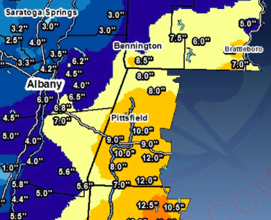
Even though this week was a bust, we are excited about a possible Sunday/Monday storm. (We know, once bitten twice shy. But we really mean in it this time.) The model runs are showing all kinds of scenarios, but several runs do show phasing of two low-pressure systems and a coastal storm developing. And you know what that means. It's highly likely we will get light snow (1-3 inches), but the possibility exists for a snow-day-inducing event Sunday night. As the GSD Staff has recommended for many years that the day after the Super Bowl be a national holiday, we are intensely rooting for this storm to develop.

While this map does not show a direct hit, it does show that a coastal storm is in the forecast for Sunday and Monday. We just need to storm to hug closer to the coast and we're looking at 8-12 inches for much of New England.

Definitely keep your ears open for possible delays Thursday and Friday--even though the chances are slim--and keep your fingers crossed for a coastal storm for Sunday night.

Monday, January 29, 2018

Snow Update the Week of January 29

The ever-changing weather landscape means we have to reverse course on the first part of our optimistic outlook for snow this week.

The coastal storm we were hoping for will develop, but it will be just a bit outside. Downeast Maine will receive the brunt of the storm.

The end of the week storm is still very much up in the air. Pieces are in place for a strong storm that develops out of the Ohio Valley and gains strength with energy from the coast. This storm has the potential to bring us heavy snow. The good news is that the timing his improved markedly. If it develops, it will drop snow on us starting Thursday afternoon into Friday, and we will see delays and snow days.

You may see a few flakes tonight due to the coastal storm, but there won't be any accumulation. Temperatures this week will mostly be in 30s, and then with the arrival of the late-week storm we'll see the mercury drop back into the 20s for the weekend.

Keep your fingers crossed about this developing snow situation. But if we do strike out on Friday, it looks like a few more storms are in the pipeline for next week. The good news is we've returned to a very active weather pattern.

Saturday, January 27, 2018

The Triumphant Return of Snow

Spring has not sprung; the grass has not riz. Winter is making a comeback and will impact our area next week.

We have our meteorological eyeballs fixed on two events next week. The first one, which will be lighter, could impact the Tuesday morning commute to school. The second one could impact the length of the day on Friday.

Folks at Accuweather are more optimistic about this storm than our local meteorologists are.
There are few indicators that the Monday/Tuesday storm could be a sleeper and develop into a more coastally enhanced event, but right now the expectation is for 1-3 inches starting late Monday night and lasting throughout the day on Tuesday. The models aren't doing much with the storm, but there seems to be enough energy in place for it to develop into a moderate snowstorm, especially for South County and southern and southeastern New England. If it fully develops, we could see 4" north of Pittsfield and 6 inches in South County. If.

The storm at the end of the week has the potential to bring heavy snow to the Northeast. There's still a lot of uncertainty with, but we won't be surprised to see a nor'easter develop on Friday. Our only concern is that it will develop too late on Friday to give us widespread snow days. Early releases might be our only hope.

All of this is good news for us snow lovers. If we could add 10 inches to the seasonal snow total next week--a distinct possibility--skiers, sledders, and snowshoers should have enough of a base of snow to get them through the end of February, as we are expecting #arcticgeddon beginning in early February.

Keep your eyes peeled and your ears open. More to follow tomorrow.

Monday, January 22, 2018

Winter Weather Advisory and News and Notes

The National Weather Service has announced a Winter Weather Advisory for patchy frozen precipitation of various kinds this evening and tomorrow morning for Northern Berkshire county only. There's just the slightest chance of delays on Tuesday for Adams-Cheshire, Florida, Clarksburg, and Savoy, but most students will be unaffected. If you're reading this, it is officially, as they say, on your radar.

And some other news...

The government shutdown is not good for weather brokers like ourselves. We tried to do some research at the National Oceanic and Atmospheric Administration (NOAA) website and got shot down. Some parts of the website are working--those having to do with the weather safety--but everything else will return at a later date.

And finally, brace yourselves for a brutal February. There is lots of talk about the return of subzero temperatures after the first week of February. The well-known long-term forecasters are all over the story of the returning cold temperatures. And if it's anything like December, we'll be looking at freeze delays and freeze cancellations in the week before February vacation. This is all a few weeks off, and you should expect to see a lot of coverage in the mainstream media as we get closer to the arrival of the potentially record-setting cold air.

Watch those roads tonight and tomorrow morning for slick spots.

Saturday, January 20, 2018

January Thaw

We're entering the doldrums of winter. The holidays are over, we just had MLK Jr. Day, the Super Bowl is not for another two weeks, and the next vacation is over a month away. And to top it all off, we have a map to show you that will make you very sad.


This is the predicted temperature forecast for the end of January. That is not the map that those in the snow day business want to see. We'll get precipitation during this time, but it will be in the form of rain. Case in point: Monday-night-into-Tuesday's storm. We could see an inch of rain out of this weather disturbance by the end of the day Tuesday. Normally at this time of year, one inch of liquid would generate roughly 12 inches of snow. But not this time, as temperatures will be in the low 40s.

A look ahead at the forecast models show that for 10 of the next 12 days, we will see temperatures north of the freezing mark. This brings us great sadness.

The GSD Staff definitely thinks that Old Man Winter has a few more whoppers in store for the Berkshires before this winter runs its course--and some forecasters think that in February we'll see a cold snap similar to the one we experienced in December--but we're entering a very quiet phase that will last for at least two weeks.

Wednesday, January 17, 2018

Missed Calls?

While most students in Berkshire County are enjoying a day off today, a few had to go in late, especially in South County. But the good news for them is that their Superintendents seemed to make the right goal, and that's one less day in June for them. Well done. The gamble paid off.

It's hard to fault those Supers who called in the snow day, though. The Winter Storm Warning was in effect, the radar suggesting several more inches of snow, and meteorological outposts (including this one) were predicting more snow. But the intensity of the snow was lacking, which would have made it possible for most students to get to school, as long road crews were doing a good job (which they were doing in and around the GSD Home Office in Williamstown).

As for snow totals, we have 7" on the ground right now, and it's possible we could add another inch if the band of snow over Albany right now (12 PM) pushes eastward. Don't be surprised to see another few hours of light snow especially in the northern half of the County this afternoon.

Light to moderate snow expected for northwest Berkshire County.
It could be a while until our next storm. We'll see a warm-up over the weekend and into next week. The back half of January is supposed to be warmer than average, and a cold snap is expected for early February. Don't forget that February is typically our stormiest and snowiest month. So we have that to look forward to if we have a dry spell over the next few weeks.

(If you didn't see it this morning, there was a piece on GSD in the Berkshire Eagle this morning, expertly written by Felix Carroll. The man featured in the article certainly does work for GSD, but for him to claim that this operation is a one-man show is preposterous. In fact, we're having a staff meeting this very afternoon to talk about what it means to be a team player.)

January 17 Storm: Cancellations and Delays

Light snow continues to fall at the Home Office, and plows have been out all night. We see several more hours of snow ahead of us.

There are some heavier bands of snow making their way northeastward from Pennsylvania and New York that will hit during the morning commute. Once those bands pass through, snow will be generally light and it should taper by the early afternoon.

Heavy snow bands over eastern PA will trek toward us right around the time of the morning commute.
The low-pressure system off the coast is keeping the moisture levels up. Everyone should see at least another 3 inches of snow today, with more likely in South County due to those heavier bands of snow.

Thanks, NWS Albany, for the graphic.
Here's our list of school day delays and cancellations. We'll update as the calls come in this morning.

SNOW DAY:

Berkshire Christian
Berkshire Country Day
Berkshire Community College
Central Berkshire
Southern Berkshire
Gabriel Abbott
Northern Berkshire Vocational (McCann)
Hancock
Emma Miller
BArT
Housatonic Academy
Mount Greylock
Williamstown
Lanesborough
Adams-Cheshire
Pittsfield
North Adams
Bement School
New Lebanon (NY)
Southwest VT Supervisory Union
Farmington River
Mohawk Regional

TWO-HOUR DELAY

MCLA (opens at 10 AM)
Lee
Pine Cobble
Lenox
Richmond Consolidated
Berkshire Hills


Tuesday, January 16, 2018

Cancellations and Delays: January 17

(For substantive weather information, here's our earlier post.) We said we'd run a list if one district called in its verdict tonight, and here it is:

SNOW DAY:

Farmington River School District

January 16/17 Storm: Early Evening Report

After a day of light snow--3 inches on the ground at the GSD Home Office (as of 7 PM)--we're girding ourselves for another 6 inches of snow overnight. The morning commute will be a mess, and we expect delays and snow days for almost all students in Berkshire County tomorrow.

Here's a fascinating comparison. First, is the current radar:


Here is this morning's radar, over 12 hours earlier:


Not a lot of change, right? We can see the snow starting to fill in in New York and Western New England, and there is a clearly defined boundary for this storm. Fortunately, we are living on the right side of the tracks for this snow event.

We do expect the coastal low--you can start to see it beginning to take shape off the coast of New Jersey in the top image--to throw some snow at us in the form of those heavy bands of snow. Those bands will be the magic ingredient for a snow day tomorrow.

The forecast is for the snow to last right on through to midday. Perhaps it ends around 11 AM in South County and holds off until 1 PM in North County. But the ends of these things are harder to predict than the beginnings. (Maybe because once we get that snow day we lose a little bit of interest in the storm. Just a theory.)

It's about at this point in our early evening storm posts that we write about whether or not your Suprintendent will take away the suspense and phone in the delay or snow day tonight. We're sure there will be a few, but we think Superintendents want to wait this one out as A) we just had a day off Monday; and B) a lot of high schools are in mid-term exam time and no one wants to mess with those schedules--giant headache. On a positive note, a ton of districts in counties to our east have already phoned in the cancellation. Mohawk Trail and Greenfield are both off tomorrow.

Given that NWS Albany expects 6-10 inches for Western Mass, we'll bump up the chance of a delay to 95% and push the snow day to 80%. You can probably get away with blowing off your homework tonight, but if you have an exam tomorrow, you should put in a little study time just in case. Plus, if we do get the snow day, then you have a leisurely day ahead of you.

As soon as a single, solitary Berkshire County Superintendent breaks the ice, we'll start a running list of delays and cancellation decisions.


Wednesday Storm: Midday Report

Here's a really nice forecast map of the projected snowfall for this storm:

Thanks to Joe Bastardi for this image.
If you zoom in, here's what you'll see:


That purple blob indicates we are in line for 6-10 inches, with the eastern portion of Berkshire County closer to 10 inches and towns on the New York border closer to 6 inches. What's fascinating about this storm is how confident meteorologists are about the range of snowfall we're slated to get. The low end is 4 inches and the high end is 10 inches. For our last storm, our low end was an inch and the high end was 12-14 inches. This means that there is more certainty about the track of the storm, thus raising the chances for widespread snow days tomorrow.

The big factor that will affect our total snow amounts will be if "mesoscale banding" takes place. Essentially, this means bands, or waves, of very intense snow will move out across our area from the center of the storm off the coast. These bands could produce snowfall rates of 1-2 inches per hour. Snow will pile up quickly at that rate if banding occurs.

Schools are already starting to call off afternoon activities. Right now we know that North Adams and Mount Greylock have called off all of their practices, rehearsals, club meetings, and games for the evening. If you know that your school has canceled activities, add them to our Facebook page or in the comment section here.

To repeat from our earlier report: the snow you are seeing right now is not really part of the main storm. That will come tonight, and the intensity will be much higher than it is right now. Expect the heavy snow to start to come down between 7 and 9 PM.

Winter Storm Warning For The Berkshires

Excellent news, dear Followers of the Flake. Around 3:30 AM on Tuesday, the National Weather Service declared a Winter Storm Warning for the Berkshires that begins at 5 PM tonight and ends at 3 PM tomorrow. Most meteorologists are now expecting 6-9 inches to blanket the Berks.

There are two components to this storm. First, there is a minor low-pressure system coming out of the Great Lakes that will give us snow throughout the day today. A giant swath (see below) of snow stretching all the way back to Texas will gradually press northeastward--moving directly over Berkshire County--and give us light snow throughout the day today. Expect 2-3 inches on the ground by sundown due to phase I of the storm.

The 5 AM radar. That is one long swath of snow, and it will track right over us throughout the day today.

But the real snowmaker for us will be a coastal low-pressure system that is supposed to form off the mid-Atlantic coast and track toward Cape Cod. This storm will gain in strength as it forms and moves northeastward. If it behaves the way the models say it will, snow will intensify later this evening and well into the day tomorrow, with periods of heavy snow--one inch per hour--expected.

A few days ago the forecast was for the snow to end shortly after the morning commute on Wednesday. Now, the storm looks to be ending in the early afternoon. This is the best piece of new information for those desperate for a snow day tomorrow.

Superintendents are between a rock and a hard place on this storm. It's been hard to get into an academic rhythm lately with the snow and freeze situation on January 4th/5th and MLK Jr. Day yesterday, so they might be reluctant to make the call tomorrow. But the perfect timing of this storm will likely force their hands, and they will have to call in the snow day.

Thanks, NWS Albany, for the map.
We'll have much more later today on this storm--projected snowfall totals keep going up--but our early prediction is for mostly snow days tomorrow if the storm behaves as expected, and mostly delays if it busts. Games and performances tonight will have to be postponed.

Monday, January 15, 2018

Storm Approaches; Snow Begins Tomorrow Before Noon

We're all systems go for a moderate snowstorm for Tuesday and Wednesday. The GSD Staff is encouraged by the reports coming in about this storm, and most students should have the length of their school day affected in some way on Wednesday.

The NWS map keeps improving. Yes, NWS!
We have not seen the Watch upgraded to a Warning, so we'll hold off on total confidence in delays or snow days for Wednesday. Plus, this is not a blockbuster storm. It's a good moderate storm, but it's not a slam dunk.

Even if Berkshire County stays in the Watch zone until the onset of the storm, we're still expected to get a solid 4-6 inches of snow, with as much as 8 inches in some places (east-facing slopes of the Berkshire mountains and hills). The models are showing slightly more moisture with this storm than was originally forecasted, which is great to see. There is a chance we'll get moved to a Winter Storm Warning overnight tonight or early in the morning tomorrow.

Expect snow to start by late morning on Tuesday and last all the way through late morning on Wednesday. If this storm performs as expected, there will be a few strong bands of snow overnight Tuesday. We don't think many districts will make their call on Tuesday night, but the trend has been toward early announcements, so we could be entirely wrong on that front.

Not bad for WNYT, this early in the proceedings. Another encouraging sign.
Games and performances on Tuesday night are likely to be postponed due to the snow. Two to four inches should be on the ground by that time. Practices after school will be entirely dependent on the confidence and/or skittishness of your Superintendent.

We'll update you all throughout the day on Tuesday.

Upgraded: Winter Storm Watch For Tuesday Night & Wednesday

Greetings, Flake Followers. We have some good news to report. The National Weather Service has decided to drop a Winter Storm Watch on the Berkshires. This means we have the potential for 6+ inches of snow within a 24-hour period. This is a much rosier picture than the one we gave you yesterday.

The Watch period begins in the afternoon on Tuesday and ends Wednesday midmorning. So, you can see that it's not supposed to snow for that long.

Significant NWS upgrade.
The reason for the sudden announcement of a Watch is that the storm is supposed to stall over us slightly and allow energy from a coastal low off the Delmarva peninsula to join into the fun. We could see moderate and heavy bands of snow from this storm, which could get us close to 6 inches, which is essentially the magic number when it comes to snow days. Three to five inches feels skimpy; six inches has enough heft to it.

Coastal storm involvement courtesy of Accuweather.
The two items of concern are: 1) snow day Wednesday? 2) games/evening activities Tuesday? Right now we'll put the True North Confidence Meter at 33% for cancellations of both. The timing is just right to spoil the fun Tuesday night and bring students merriment on Wednesday morning.

If you want that snow day, let me hear you say [chanting] "Three Day Week! Three Day Week!"

We'll have more later today on this developing snow event. Cross-country skiers and sledders might get to do their things after all.

Sunday, January 14, 2018

Midweek Snow: Not As Much As We'd Like

After the craziness of yesterday's flooding and rapidly falling temperatures, today (Sunday) turned out to be a frigid but calm day. Once again we're heading near the 0 mark on the thermometer, but the wind chill will not really be an issue.

Our midweek snowstorm will unfortunately stay as an Alberta Clipper and not develop as a coastal storm, as we were hoping it would. (Actually, it could develop as a coastal storm but that will happen off the coast of Maine and not impact our area much at all.) This means snow totals will be in the 1-3 inch range. It will probably not be enough to satisfy our cross country skiers and sledders, but it will cover the ground completely.

Good, but probably not good enough.
We will see snow this week. We should see a period of snow Monday evening, then snow showers throughout the day on Tuesday. The heaviest of this light snow event should then fall Tuesday night, perhaps lasting into Wednesday morning's commute. Our radar is up for possible delays on Wednesday, but overall the GSD Staff is not "feeling it" on this storm.

We'll monitor the Wednesday morning situation as we get closer to it. For now, enjoy MLK Jr. Day and the return of snow on Monday night.

Friday, January 12, 2018

Winter Weather Advisory for Saturday

A wide array of types of weather is currently bombarding and will bombard Berkshire County today and tomorrow.

Flash Flood Warnings have been declared for our area due to the heavy rain and melting snow. This Warning will expire at 4:45 this afternoon. Watch for streams and rivers that are close to roads.

A Winter Weather Advisory is in effect starting late tonight and lasting through the day tomorrow. The temperature will sink like a stone and make for a messy period of travel in the morning tomorrow. Roads will ice over, and any lingering rain showers will turn to sleet and snow. You should see this switchover between 5 AM and 10 AM tomorrow. As long as road crews are out ahead of this period of the storm, travel should be slow but fine.

Some of the signs we need to see ahead of a snowstorm are beginning to materialize for a midweek snowstorm. Again, the North American model gives us a stronger storm; the Euro's forecast model is less strong but still calls for widespread snow for our area. Right now the range could be 1-2 at the worst and 6-8 at best. This potential storm is trending in the right direction as of now.

Accuweather thinks we'll see snow next week.
Be careful on the roads tonight and tomorrow morning. And all hands are on deck monitoring the midweek snowstorm potential.


Thursday, January 11, 2018

Bye-Bye Snow

Spring-like warmth has returned to Berkshires. We got to 50 degrees at the GSD Home Office today, and with mid-50s readings expected tomorrow--along with over an inch of rain--our cozy foot of snow will be washed out. Alas.

A flood watch is in effect tomorrow into Saturday due to all the rain and melting snow.

The good news is the cold air will not be gone for long. On Sunday morning, you will once again awake to single digits, and the highs on Sunday will struggle to get into the teens. We will see a moderation of the temperatures toward more normal highs and lows as the week progresses, which sets up the conditions for snow.

Speaking of snow, our consultants are suggesting a storm could happen Tuesday night into Wednesday. A classic two-systems-converging storm event might impact the Berkshires. The North American model is stronger on this storm than the European. The North American did pretty well last time around, so this is a good sign.

If all comes to fruition, we could see a 5 to 9-inch blanket on the Berkshires. We will certainly slow our roll on this storm for now, but it has definitely piqued our interest.

The precipitation forecast for Tuesday/Wednesday. Half an inch of precip would yield about half a foot of snow. We like it!
Get out the rain slicker tonight--you're going to need it for the next few days.

Sunday, January 7, 2018

Light Snow For Monday

Wow. What a crazy week we just had. Sub-zero temps. Incredibly low wind chills. An overperforming snow storm. Freeze delays, early releases, snow days, freeze days. We had it all in Berkshire County last week.

This week will be active, but we won't be seeing any newsmaking weather events. (That's probably not a good thing, given how much fun the regular news is these days.)

Snow will be in the air tomorrow, with the roads getting a coating at some point midday. The ride home from school might be a little slow, but this minor Alberta clipper is not a big deal.

Later in the week we'll see a big warmup. There's an outside chance we could see 50 in some parts on Friday. We do not like this trend one bit, as it is January in New England, and temps should not leave the 30s.

In terms of plowable/shovelable snow, we're not seeing anything until the middle of next week, and that's a low confidence forecast.

It's looking like a full week of school for everyone until Martin Luther King, Jr. day. We'll check back in if we hear anything you need to be concerned about.


Saturday, January 6, 2018

Record Cold Tonight; Snow Showers For Monday

To those of you who have had up to here with the cold: relief is in sight. Tomorrow will still be cold--highs in the teens in the afternoon--but there will be no wind, and the work week begins with temps in the 30s. And to end the week we'll be in the mid-40s. The cold snap will be over.

Today, though, will be miserable. It's -3 at the GSD Home Office, and we do not expect to see much northern movement of the mercury. Also, the wind continues to be gusty, bringing wind chill values close to -30 degrees. If you go outside, make sure you cover your skin. Tonight the wind will die down and, with no cloud cover, there will be what is called radiational cooling. Temps will get to -13 to -16 in the Berkshires tonight. Great googly moogly, that's cold.


We do have snow in the forecast. A weak system will move across our area during the day Monday. We could see a dusting up to an inch, but there's not too much to worry about there. After school activities should not be affected.

The weather forecast for later in the week is less certain. Again, it's the battle of the models. The North American gives us a chance of light snow overnight on Wednesday while the Euro keeps us high and dry and warmer. Let's just say right now that there is a chance for unsettled weather, with rain likely at some point, between the early hours of Thursday and Saturday evening.


Friday, January 5, 2018

Freeze Days and Delays

This morning the snow has stopped, the wind is howling, and the temperature sits at a chilly 5 degrees. Wind chill values are approaching -20 degrees. Most schools have called in their verdict for today,  Here's our current list, and we'll be updating it for the next hour or so. It's the inverse of yesterday's list--South County schools are going with the delays, while everyone north of Great Barrington is off (of those districts that have made their decision)

FREEZE DAY

Berkshire Country Day
Southern Berkshire
Berkshire Community College
Lee
Lenox
Pittsfield
Pine Cobble
Emma Miller
Southwest Vermont SU
Southern Vermont College
Stamford VT
Central Berkshire
BArT
Farmington River
Emma Miller
Gabriel Abbott
McCann
Clarksburg
Adams/Cheshire
North Adams
Mount Greylock
Williamstown
Lanesborough
Hancock
Williams College (administrative offices and day school)
Mohawk Trail

2-HOUR DELAY

Berkshire Hills
Richmond

As we go through the morning, here are some fun maps to look at. These were produced yesterday afternoon or night:

Recorded snowfall for Thursday's storm. Generally speaking, this storm overperformed.


No snow totals will break any records, but the cold on the backside of the storm might.

Please stay inside if you can over the next few days. We'll have a big warmup on Monday and Tuesday, with temps in the low 30s. Break out the shorts!

Thursday, January 4, 2018

Wind Chill Warning & Winter Weather Advisory

Currently, we are under two different alerts for Berkshire County. One is a Winter Weather Advisory, which is slated to last through Sunday morning. This Advisory is due to the dangerously low temperatures as well as the blowing and drifting of the close to 8 inches that fell in most of Berkshire County.

The other is a Wind Chill Advisory that will then turn over to the more severe Wind Chill Warning. The Warning will kick in at 1 AM tonight and last through Saturday evening. The Warning calls for dangerously low Wind Chills, perhaps getting to as low as -35. The NWS is quick to tell us that frostbite can kick in in these unusually cold temperatures in 10 minutes.

Because of the dangerously cold conditions tomorrow morning, the GSD Staff thinks that several schools will do what they can to prevent students from having to wait at bus stops. These preventative measures could come in the form of delays and/or full snow days. While it won't be quite as cold as it was Tuesday (when we did get freeze delays), the wind chill will make it feel much colder. Plus, there will be snow blowing sideways, and that's always fun.

The GSD Staffers are a bunch of hearty New Englanders, and as much as we advocate for snow days, we also find it it admirable to tough out the harsh weather. But we draw the line at the ultra cold. Snow in and of itself is not dangerous; temps in the -20s are neither fun nor safe.

And on that cheery note, we do have a few delays and closures to report for tomorrow. We'll start the running list here:

FREEZE DAY

Central Berkshire
BArT
Farmington River
Emma Miller
Gabriel Abbott
McCann
Clarksburg
Adams/Cheshire
North Adams
Mount Greylock
Williamstown
Lanesborough
Hancock
Williams College (administrative offices and day school)
Mohawk Trail

2-HOUR DELAY

Southern Berkshire
Berkshire Hills
Richmond
Southwest Vermont SU
Stamford VT
Berkshire Country Day

Freeze-y Friday

It's never too early to start thinking about snow day/freeze day #2 of 2018. We're off to a rip-roaring start, and we also like what the weather maps are showing us for next week. (But we'll hold off on those prognistications until we get through this deep freeze.)

So far, this storm is living up to expectations. Moderate and heavy snow bands are making their way through Berkshire County. The North County schools may have trimmed things just a wee bit close as roads were snow-covered and untreated when the children were released into the wild between 11 and 12.

1:45 PM radar: a classic Nor'easter
We expect the snow to stop between 10 and midnight. We should be in the 6-7 inch range when it's all said and done.

Even with the snow stopping tonight, blowing snow and frigid temperatures will be the big issues tomorrow morning. Poor road conditions could lead to delays tomorrow. Frigid temperatures--wind chills approaching -20 degress--could also lead to delays and freeze days tomorrow.

The other complication for Superintendents is that we will see high temperatures in the low single digits tomorrow, with the temperature dropping throughout the day (atypical). Because of the cold and the fear of stalling busses, the will of the bus company tomorrow is what will largely drive Superintendents' decisions for the length of the school day on Friday.

We'll probably see a few schools call in tonight, but most of you will have to sweat it out in the morning. The blowing snow and freeze should give at least half the schools in Berkshire County some extra time off tomorrow (delays or freeze days). Farmington River is already in with the 2-hour delay, but they made that decision yesterday.

Thursday MegaStorm: It's On

Light snow has broken out in much of Berkshire County. A few fingers of light snow have reached out across Berkshire County, but the heavy stuff is off to our south and will be hitting us later this morning and into the afternoon.

The 5 AM radar
Most schools will have a shortened day or no school at all. We do expect a few early releases to change to snow days. Here's our running list, which will update as the calls come in.

SNOW DAY:

MCLA
Berkshire Community College
Lee
BArT
Lenox
Central Berkshire
Pittsfield
Southwest Vermont SU (Mt. Anthony)
Berkshire Christian
Emma Miller Memorial
Southern Berkshire
Berkshire Hills
Richmond Consolidated
Berkshire Country Day
Farmington River
Southern Vermont College
Mohawk Trail
The Bement School

EARLY RELEASE:

Pine Cobble
Adams Cheshire
Mount Greylock
Williamstown
Lanesborough
Hancock
North Adams
Clarksburg

Wednesday, January 3, 2018

Thursday Storm: Late Evening Report

Hello again, Flake Followers. Sorry for the delay in getting this post out. All sorts of school decisions came in earlier in the evening, and if you checked in on Twitter you know where we stand on that front.

We have not heard from many districts, so you're going to have to set the alarm for tomorrow to find out your fate if your not on the list below. If you are on the Early Release list, there's certainly a chance you'll be upgraded to the full snow day.

Here's the skinny:

The amount of snow looks good: 5-9 inches.
The timing has improved significantly: storm starts between 5 and 7 AM.
The mindset of the Superintendent is unclear: many school heads still seem to reeling from last year's onslaught of snow days and are reluctant this year.
Wildcard factor: blowing and drifting snow; 40 MPH predicted in the afternoons.

Here are the maps. A few are not very inspiring:


Let's hope the earlier NWS-Albany map is "righter" than these. There should be enough snow to warrant many snow days, but we'll know more tomorrow morning. The radar looks like we will get hit hard, but it is a fast-mover.

We'll run a list of cancellations and early releases starting early tomorrow morning. To recap, here's what we have so far:

SNOW DAY:

Berkshire Hills
Richmond Consolidated
Berkshire Country Day
Farmington River
Southern Vermont College
Mohawk Trail

EARLY RELEASE:

Mount Greylock
Williamstown
Lanesborough
Hancock
North Adams
Clarksburg

Thursday Storm: Early Evening Report

All systems are go so far with this storm. It's actually now scheduled to come in earlier--between 5 AM and 6:30 AM. This is great news. You can see expected snow totals below.

We'll have a longer report around 9 PM.


Here's the latest snow forecast from NWS-Albany:


With the forcast of 40 to 50 MPH wind gusts in the afternoon on Thursday, conditions are ripe for county-wide cancellations tomorrow.

If cancellations come in (Mohawk Trail has already pulled the parachute cord for tomorrow), we will update them on our Twitter feed: @GreylockSnowDa1.


Winter Storm Warning for Berkshire County

Things are looking up, Flake Followers. We've been upgraded. NWS-Albany is now calling for 6-8 inches of snow for our area, with some spots seeing as much as 10 inches (eastern sections of Berkshire County). This snow will be light and fluffy, which should allow it to pile up in a hurry.

The other weather advisory for our area, the Wind Chill Watch, could have as much as an impact on the length of the school day as the snow does. We're expected to see very blustery conditions throughout the day and into Saturday morning. Plows might be able to clear the roads, but the blowing of snow will negate their efforts in a hurry.

We will raise the True North Confidence Meter several percentage points. One thing is assured: there will be no afternoon or evening activities after school tomorrow.

Maps are coming tonight. Love the maps!

Thursday Storm Morning Report

Last minute adjustments are coming in about this winter hurricane, and some of the models are pushing the storm's track more to the west. West is good; east is bad.

What started as a 1-3" snow storm has now become a  3-5" storm with 4-6" on the eastern facing slopes of the Berkshire Hills.

Here's a very interesting Twitter update from Boston meteorologist Dave Epstein:

If you can't read the fine print: "One of the models we use is showing up westward jog so much that it brings rain into Boston during storm. Will awaait the afternoon date before making changes."
If that model he's looking at proves to be true--and it might be a red herring--then we could see 6-9 inches of snow in Berkshire County.

We're also closely monitoring the timing of the storm. The timing is the main factor that the GSD Staff is focusing on right now. Here's a helpful map from NWS-Albany:


The timing is improving (from two days ago), but we'd be more comfortable if it would speed up by an hour or two. Then again, if our Winter Weather Advisory gets upgraded to a Winter Storm Warning at some point today, then the timing really won't matter and we'll be looking at widespread snow days.

We're upgrading the True North Confidence Meter, but we're hardly all in on full snow days for tomorrow.

Tuesday, January 2, 2018

Thursday Snow

Just like that and we're right back into the winter storm groove. All signs are pointing to a snowy day on Thursday. We are just on the fringe of a potentially historically large coastal storm, or "a winter hurricane," as the Washington Post is calling it. This is a massive storm, but mostly acquatic creatures will feel the brunt of it.

Good news: we've seen slight uptick in the amount of snow forecast for our area on Thursday. We're now expecting 3-4 inches for most of the county, with possibly of more in the eastern part of the county.


What's really interesting is the range in the forecast for snow. Most models are suggesting 3-4 inches. Some model runs indicate just a trace of snow. But on the other end, some model runs are calling for 10 inches for the Berkshires.

What does this mean? First, we're more likely than not to get 2-4 inches of snow, as that's what most models are showing. Second, we're not far away from very heavy snowfall. We are not encouraging you to get your hopes up, but if the storm hugs the coast a little tighter, we could easily see our snow fall totals double.

There is bad news. The timing of the storm is not working for us on Thursday. It could be snowing by the morning commute in South County, but it looks like the snow will hold off until midmorning. But the afternoon commute home will be dicey, and we will see many schools call off practices and games Thursday afternoon and night if the storm behaves as expected.

So, while it will be nice to get a fresh few inches of snow on top of our old snow, we don't think much is going to happen on the school closing/delay/early release front. A few skittish Superintendents might go with a snow day or an early release, but the GSD Staff is not putting up a lot of True North Confidence Meter percentage points on those outcomes.

We should see a Winter Weather Advisory announced for Berkshire County by midday tomorrow. If the NWS announces a Winter Storm Watch or Warning, that's a great sign: we'll be in line for 4-8 inches of snow. Bet on the Advisory, and keep your fingers crossed that the storm starts a few hours earlier than expected.

The snow on Thursday will be one story to follow, but the cold on Friday and Saturday will be an even bigger story. How cold will it be Saturday? The Berkshire County cross country ski races slated for Saturday have been moved to Sunday, and we're sure that most outdoor events will have to be postponed. It's possible the high temperature for most that day will not reach zero.

Sunday and Monday look much milder. We also are eyeing some messy weather Monday and Tuesday of next week.

Much more tomorrow!

Monday, January 1, 2018

Freeze Delays Reported!

We have several schools that have called in a freeze delay for today. The temp has risen during the evening due to thin cloud covering--+5 at the GSD Home Office--which means we will likely not be adding too many more schools to this list.

Here's who has a delay.  We will continue to add to it should more delays come in.

2-HOUR DELAY:

Farmington River
Southwest Vermont SU
Mohawk Trail
Southern Berkshire
Stamford (VT)
Emma Miller Memorial

FREEZE DAY:

Mt. Anthony Union Middle School (frozen pipes)

First Forecast of 2018

Happy New Year, dear readers. It is a balmy -16 degrees at the GSD Home Office this morning, but there's no wind at the moment, so we've got that, which is nice. We do have a Wind Chill Warning in effect, though, through 1 PM today, and we bet that gets extended. If you need to go out, layer up.

New Year's greetings from Old Man Winter
A few days ago we hinted at a big midweek storm. While we do think we'll see a few inches from that storm, mostly it's going out to sea. During the day on Thursday we'll see light snow, but unfortunately it does not look like it will impact the length of the school day. We might see a few games canceled in the evening, but the chance of that happening is still relatively low. It will be a very big storm, but for Down East Maine, Nova Scotia, and New Brunswick.

The big impact of this storm on the Berkshires will be on the temperatures in its aftermath. As it lifts well to our northeast, bitterly cold air will wrap around it (counterclockwise) and flood into our area. This means that on Friday, the high temperature will be somewhere around 0. On Saturday, the high temperature could be in the negative numbers. This is unusual and should not be taken lightly.

Low temps this weekend will be around -15 degrees each morning.

The GSD Staff is sure that you are wondering about freeze delays. Unfortunately, the timing isn't working for us. There is no question that some districts would delay the start of the school day with temperature readings of 15 degrees below zero. But the lowest temps were expecting on any school day mornings is 1 or 2 degrees below zero on Friday.

We'll keep an eye on the Thursday storm for certain. It's close enough to our region that a change in the track could give us 3-6 inches of snow instead of the 1-2 inches that are predicted right now.

We wish we had better news for this week. But for the long-term forecast we are hearing about a return to a more active storm pattern after this first week of 2018.