So, it looks like the North American wins this week's battle of the models. The big storm we were eyeing will now be a dusting or at most an inch in Southern Berkshire County.
The big issue, though, is the cold. It's possible we could stay in the single digits and teens all way through next weekend. If we were to have school on Monday, we would probably see some freeze delays as temps on Monday morning are supposed to bottom out between -8 and -15 for Berkshire County.
As for the snowcast, we might see a flurry Friday night and the aforementioned Saturday dusting. Then, on Wednesday we could see a period of light snow in the evening followed by something much bigger for the end of the week. Again, the meteorological scuttlebutt is centering on a significant coastal storm.
We won't hold our breath on that one, but the one thing for sure is there is plenty of cold air in place for any precipitation to come down as snow and only snow. And because it is so darn cold, the snow-to-liquid ratios will be very high. In other words, we won't need a lot of precipitation to produce many inches of snow.
Stay warm!
Thursday, December 28, 2017
Wednesday, December 27, 2017
Weekend Storm Uncertainty
There has been a lot of speculation about this weekend's potential snowstorm, but there is very little certainty.
The reason for such meteorological equivocation is a classic showdown between the two major weather models, the European and the North American. The European wants to phase the two storm systems into one more potent one; the North American keeps the storm much farther to our south.
Traditionally we have sided with the European, as have some of our key consultants.
Because there is so much uncertainty, we do not think that this storm is going to pan out and dump a lot of snow on us. We could see 2-4 inches starting late Friday night, but this is a very early and crude attempt to give this storm some kind of identity. As you can see, the NWS is even skeptical about snow for the weekend for our area.
Be aware that we have a Wind Chill Warning in effect for Berkshire County tonight until midday tomorrow. Wind Chill values of -25 degrees are possible in the next 24 hours. If you can swing, just stay indoors.
More about the big Battle of the Models tomorrow.
The reason for such meteorological equivocation is a classic showdown between the two major weather models, the European and the North American. The European wants to phase the two storm systems into one more potent one; the North American keeps the storm much farther to our south.
Traditionally we have sided with the European, as have some of our key consultants.
 |
| The NWS is going very conservative with the forecast for the weekend storm...so far. |
Be aware that we have a Wind Chill Warning in effect for Berkshire County tonight until midday tomorrow. Wind Chill values of -25 degrees are possible in the next 24 hours. If you can swing, just stay indoors.
More about the big Battle of the Models tomorrow.
Tuesday, December 26, 2017
Cold Snap and Weekend Storm
It's a good time to be a GSD Staffer, as we have lots to talk about.
First up is the bitterly cold air mass that has descended upon us. Goodbye, Temps in the Twenties! We'll see you in about 10 days.
The next 10 days will be very cold--we'll below normal--and the very worst of those times, when you will not want to be outside for very long, will be this Thursday and next Tuesday. Highs in the single digits on those days, with the lows nearing -10. Yes, this means we will be discussing possible freeze delays for students on Tuesday, but that's a long way off and the weekend storm--if it develops--could scramble things up and change that forecast.
The reason we're entertaining the idea of a big storm this weekend is that key ingredients are in play for the formation of a nor'easter. There are two storms out there, and they could possibly join forces to make a mega-storm on the coast. One storm is fairly weak and will make its way due east out of the plains. The other storm is down there in the Gulf of Mexico and will track northeastward, causing all kinds of problems in the South (ice, mainly) due to the cold air gripping eastern half of the US.
The computer models are all over the place right now, but some of them are predicting the phasing (combining) of these two storms (a.k.a. low pressure systems, pieces of energy) along the mid-Atlantic coast. If that happens, we could see a major New England snowstorm this weekend with some areas getting a foot of snow.
So what do we think? Our collective GSD gut tells us that this strong cold air in place (a.k.a. a high pressure system) will make things much harder for the joining forces of the two storms. Instead, we will see periods of light snow over the weekend but not much consistently moderate to heavy snow. That's just what our gut tells us. Things can change. It's weather. That's what it does.
Enjoy vacation week. Bundle up, especially on Thursday. Try to limit exposed skin to the air during this cold snap.
Sunday, December 24, 2017
Winter Storm Warning -- Northern Berkshire County; Winter Weather Advisory -- South County
Sorry for the late post. Staff party, family in town, egg nog, travel, et cetera, et cetera.
If students were in school tomorrow, this would be a 100% guarantee snow day for schools north of I-90, and South County schools would most likely have the day off.
We're expecting 5 to 9 inches for North County and 3 to 7 inches for the rest of the residents in Berkshire County.

Snow will begin around midnight or shortly thereafter. It will be snowing when you wake up. Despite the intensity of the snow, it will be fairly short-lived with the snow ending by mid-afternoon on Santa's big day.
But gusty winds and blowing snow will extend the storm, in a way, into the evening. As the storm whips up the New England coast, it will generate robust gusts out of the north and east, which will stir up the light and fluffy snow well into the evening.
The rest of the week looks quiet, but marrow-chilling temps are looming in the distance. We have several days of brutal cold in store, with expected high temps in the low teens and single digits Wednesday through Tuesday (Jan. 2). Break the skates out--the ponds will be frozen.
Happy Holidays, GSD Followers, and enjoy the snow tomorrow.
Saturday, December 23, 2017
All I Want For Christmas...
It looks like that snow we were supposed to get on Friday has been re-apportioned to Monday. Just yesterday we were talking about a paltry 1-3 inches of snow for Christmas Day, but those forecasts have changed significantly. It looks we're going to get some coastal low development Sunday night, and if you're a regular visitor to this website, you know what that means.

You can expect 4-8 inches of snow throughout Berkshire County. As for the timing, we think it will start snowing between 2 and 4 AM and continue through much of the day on Monday. A good ol' fashioned Christmas Day in New England.
If that news isn't enough for you, we are hearing rumblings about a major storm for next weekend. A nor'easter with 8-12 inches of snow is on the table. Try not to overhype this storm, but you should be aware of the possibility of a big one if you have travel plans during the last weekend of 2017.
Friday, December 22, 2017
Messy Travel Friday Afternoon
Kudos to the districts that called in the early release, as that seemed to be the right call for this storm. The bulk of the snow has stayed to our north so far, but there is a swath of snow and sleet headed our way this afternoon. Final snow totals will likely be well under what was projected.
Precipitation will be light today, but the snow and sleet and freezing rain will make for a slow travel anyway. Sleet and freezing rain should end later tonight (between 9 and 11) but then start up again in the late morning hours tomorrow. Eventually by Saturday afternoon we'll see a changeover to all rain, and unfortunately it will be steady. That is some bad news for cross country ski aficionados.
But if you like waking up to snow on Christmas day, 2017 is your year. While the snow will not be heavy (1-2 inches), it will be enough to set the mood and make things look real purty out there.
The only other big weather news for vacation week is the blast of cold air headed our way. We're talking Polar Vortex cold air. The meteorological crystal ball is showing highs in the low teens for New Year's weekend, with sub-zero temps at night. Let's hope Santa delivers warm winter weather gear when he makes his way down your chimneys.
Despite the week of vacation in front of us, the GSD Staff never rests. If there are any weather developments in the next ten days, you know where to find us.
December 22 Storm
It's snowing at the GSD Home Office in Williamstown--first plows went by at 4:45 AM--but unfortunately for much of Berkshire County, the snow is taking a break. The cutoff line as of 5 AM looks to be New Ashford.
The radar shows more light snow is on the way and will impact the morning ride to school for most towns in the county. We're still expecting 1-2 inches for South County and 3-4 inches north of Pittsfield by the end of the day.
Here's the 5 AM radar:

You can see that the cut off line is high, thus explaining why all the North County schools have a better crack at a snow day or early release. That piece of precipitation over Oneonta should hit us around 6:30 AM. Will it be enough to get you a delay, snow day or release (or nothing😟) is a question only your Superintendent can answer.
We will update this list as delays and cancellations come in, and we do think a few will come in for schools in the northern part of the county.
SNOW DAY:
Gabriel Abbott
Hoosick Falls (NY)
Mohawk Trail
Southwest Vermont Supervisory Union
North Adams
Adams-Cheshire
Emma L. Miller
Northern Berkshire Vocational (McCann)
BArT
EARLY RELEASE:
Mount Greylock/Williamstown/Lanesborough
Farmington River
Central Berkshire
Thursday, December 21, 2017
Friday Storm Evening Report
Timing--very good.
Superintendent--agreeable.
Snow Amount--okay
Amount of learning taking place tomorrow: no comment.
That about sums up the essentials for this storm. What's really fascinating about this storm is the Day-Before-Vacation influence. It's deep in our GSD Prediction Formula. (Believe us, it's in there.) Years of analyses have revealed that Superintendents are 60% more likely to opt for a snow day on a day before the December break than they are before the February break.
Here's a helpful image:

We like what we're seeing from this NWS image. As long as the snow is falling by 5 AM, we should see some impact on the length of the school day. Those with early releases already could see full snow days.
A recent report is raising concerns about how much snow Northern Berkshire will get. Totals might revert back to the 2-4 level. But our sources are telling us that ice is definitely creeping into the consciousnesses (that's a mouthful!) of the Superintendents. We'll have to wait until daybreak to see what the ice forecast is as we get into the morning hours.
The situation is still very much up in the air. We'll have updates starting around 5:30 AM tomorrow.
See our previous post for the latest closings and delays.
Delays and Cancellations for Friday
We will post more weather-related info later tonight, but we wanted to pass along two early decisions by Superintendents that we've learned of. We don't foresee too many other early calls, but we'll add them to this post as they come in. Two-hour delays and early releases could be upgraded tomorrow morning, so stay tuned.
SNOW DAY:
Gabriel Abbott
Hoosick Falls, NY
EARLY RELEASE:
Mount Greylock (11:15)
Lanesborough (11:50)
Williamstown (11:45)
Farmington River
SNOW DAY:
Gabriel Abbott
Hoosick Falls, NY
EARLY RELEASE:
Mount Greylock (11:15)
Lanesborough (11:50)
Williamstown (11:45)
Farmington River
Winter Weather Advisory Upgrade
The GSD Staff just got a little more excited with the most recent update from the National Weather Service. Two important developments: the Winter Weather Advisory has been expanded to Southern County, and the North County Advisory has increased projected snow totals from 2-4 inches to 3-6 inches with additional expectations for ice.
The South County Advisory is calling for 1-2 inches but with mixed precipitation. As they say, ice is nice.
The bump in the North County snowcast suggests there will be enough sustained frozen precipitation during the day on Friday to make for hazardous driving conditions for the ride in and the ride home.
Here are some of the latest maps for your perusal:


We certainly like this way the storm is trending. We'll bump up the True North Confidence Meter to 50% for North County (NC) and 30% for South County (SC). We also think delays are possible tomorrow in South County for those schools that have school. But because precipitation is expected throughout the day on Friday, delays in general will be limited.
This is probably a "snow-day-or-bust" scenario for Mount Greylock, Adams-Cheshire, North Adams, BArT, McCann and Central Berkshire. The others will be touch and go and will have to get very lucky. But it's possible.
Winter Weather Advisory for Northern Berkshire
The NWS has issued a Winter Weather Advisory for Northern Berkshire only starting at 3 AM tomorrow, which calls for 2-4 inches of snow.
The timing of our storm just improved slightly. Forecasters are saying that snow will be falling around 5 AM tomorrow. If snow days are going to happen tomorrow, this is critical step one. The earlier the snow starts, the better your chances for an extended vacation.
The GSD Staff is hesitant to forecast County-wide cancellations tomorrow because of the low forecast totals, but we do like the timing better now this morning.
For planning purposes, a second part of the storm could make travel slow tomorrow night for all of you holiday party revelers. Ice is in the forecast for Berkshire County, with more expected to the north. We could see a prolonged period of light sleet and freezing rain Friday night into the mid-morning hours of Saturday. Eventually, everything changes over to rain before the next cold front and storm move in. We'll have more later about when on Saturday the changeover to rain will occur.
The timing of our storm just improved slightly. Forecasters are saying that snow will be falling around 5 AM tomorrow. If snow days are going to happen tomorrow, this is critical step one. The earlier the snow starts, the better your chances for an extended vacation.
 |
| A noncommital map from our friends at Accuweather. |
For planning purposes, a second part of the storm could make travel slow tomorrow night for all of you holiday party revelers. Ice is in the forecast for Berkshire County, with more expected to the north. We could see a prolonged period of light sleet and freezing rain Friday night into the mid-morning hours of Saturday. Eventually, everything changes over to rain before the next cold front and storm move in. We'll have more later about when on Saturday the changeover to rain will occur.
Wednesday, December 20, 2017
Friday Snow Event
We're still on track for a measurable and plowable snow on Friday. Here's the latest snow map from the National Weather Service:
This map tends to change frequently, and we'll share their updates as they come in (usually three or four times a day).
The news we're hearing about the snow on Friday is that the cutoff line between school-canceling snow and very light snow will be very definitive. Right now I-90 is the cutoff line. South County schools are in danger of having a full day of school (except Southern Berkshire, which already has a scheduled day off. Yay for them.) Pittsfield and Central Berkshire and schools districts to the north will be in nail-biting mode on Friday morning.
The big question--aside from the relative generosity of your Superintendent--is the timing of the start of the snow. Snow around 5 AM will be great. If the snow starts around 9, we're looking at a full day of school for just about everybody. Our resources are telling us it will be very, very close to starting at 5 AM. As we process more information from the forecast models, we should be able to pinpoint the start of the storm better.
Check in tomorrow. Hopefully, we'll have good news to report. And we'll also have some info about travel plans for the weekend.
 |
| Will it be enough to extend vacation? |
The news we're hearing about the snow on Friday is that the cutoff line between school-canceling snow and very light snow will be very definitive. Right now I-90 is the cutoff line. South County schools are in danger of having a full day of school (except Southern Berkshire, which already has a scheduled day off. Yay for them.) Pittsfield and Central Berkshire and schools districts to the north will be in nail-biting mode on Friday morning.
The big question--aside from the relative generosity of your Superintendent--is the timing of the start of the snow. Snow around 5 AM will be great. If the snow starts around 9, we're looking at a full day of school for just about everybody. Our resources are telling us it will be very, very close to starting at 5 AM. As we process more information from the forecast models, we should be able to pinpoint the start of the storm better.
Check in tomorrow. Hopefully, we'll have good news to report. And we'll also have some info about travel plans for the weekend.
Friday Gift-Giving
The feel of winter will return today after a spring-like Tuesday. A cold front is moving through this morning, which could trigger a few snow showers. A dusting is possible, especially in South County before or during the morning commute.
There is good news to report. The GSD Staff has its full attention on a developing situation on Friday. Most of the models, especially the Euro, are forecasting a snowy Friday, with possible moderate snow during the day. We're seeing predictions for as low as 1" and as high as 5" for Friday. As of now, it looks like the northern half of Berkshire County will receive the bulk of the snow, with lesser amounts and even some freezing rain and sleet mixing in in the southern half.
The key, as always, will be the timing. Again, that looks good with meteorologists we trust telling us the morning commute will be affected.
So, our prevailing wisdom is that this storm is going to come down to the size of the heart of your Superintendent. A normal storm has three important factors, all of which are equally important: the timing of the storm, the amount of snow, and state of mind of the Superintendent. Because Friday is the last day before a long vacation, the formula skews toward the Superintendent's state of mind and what kind of mood he or she is in.
A Superintendent in a generous, gift-giving spirit could easily call in a snow day because of the messy conditions forecasted for the commute and the ride home and because almost all of us haven't had any snow days yet. Enjoy your extended vacation, they'll say, as they rack up a few "I'm-a-good- person" points for themselves.
A more Grinch-like Supertindent will ask students to suck it up and get to school because the roads will be snow-covered but not that bad. This Superintendent is still scarred from last year's snow day bonanza (six or seven days off in most cases). If your Superintendent has been in his or her position for a long time and/or has just signed a contract extension, have fun at school.
This all presumes the storm is going to do what we think it's going to do, which is bring us periods of moderate snow during the first half of the day on Friday.
If students were smart, and there are many of you out there, you would start a letter writing campaign immediately. You would explain to your Superintendent how nice you and your classmates have been, what good deeds you've done around the school, and ask very nicely (please, pretty please, and all that) for the one thing you want this holiday season. (One piece of advice with this strategy: the Superintendent will likely check with the Assistant Principal to see if you're on the naughty or nice list, so you may want to coordinate with your classmates who exactly sends letters in. You don't want things to backfire.)
There will be much more to come on this developing storm in the next 36 hours.
Sunday, December 17, 2017
Pre-Vacation Snow Outlook
It's hard to believe we're already nearing the December vacation week, but here we are. If there truly were a snow god/dess out there somewhere, he or she might reward us with a delay or snow day, but it's not looking likely.
We have two opportunities for delays this week. Tomorrow morning should be snowy. Because it's been so cold, any snow that falls will immediately stick to roads. Commuters will have to use caution, but it shouldn't be too bad because there isn't much moisture associated with this system. Our more cautious Superintendents might call in delays if they get a scary report from their road crews chief.
The other opportunity is on Friday. It's likely to start too late to affect the length of the school day, but we're seeing some signs that snow could start before the commute on Friday. We're too far away from that snow event to encourage you or discourage you about it. We'll know more in the middle of the week.
Keep half an eye open tomorrow morning for a possible delay.
Wednesday, December 13, 2017
Alberta Clipper Tonight
If you enjoy having snow for Santa's big day, then this is your year. Today's cold temps will lock in over the next few days, so the current few inches that are on the ground aren't going anywhere. There will be normal erosion and evaporation of the snow, but we should get enough short bursts of an inch or two in the next week or so to keep the ground covered through the end of next week.
Speaking of bursts of an inch or two, we could see another bout of snow in the Bershires tonight. An Alberta Clipper will rip across our area from the northwest and set off a period of snow from 2 AM to 6 PM. The snow will be very light and could possibly impact the morning commute. It's possible there's a very cautious Superintendent out there who would call in a delay tomorrow, but the GSD Staff does not think that that is likely.
The good news is that our meteorological crystal ball sees three more opportunities for snow in the next 10 days. There is a chance for snow Monday, Wednesday, and Friday next week. Unfortunately, these are all Clipper-type events with not much in the way of coastal low support to bump them up to moderate or major snow storms.
This means snow totals will be generally light--1 to 3 inches--and unlikely to cause cancellations. Certainly, the possibility for multiple delays exists on all three of those days if the timing is right.
We'll have more soon.
Tuesday, December 12, 2017
Winter Weather Advisory Extension for Northern Berkshire County
The Winter Weather Advisory that was supposed to end at 7 AM has been extended to noon on Wednesday for Northern Berkshire County. Those of you begging for some kind of school-shortening decision tomorrow morning just got a big boost. The chance for a delay has increased not insignificantly for the top half of the County.
This extension is actually more of a new Advisory. With the passage of the cold front through our area and enough moisture in the air, the winds will cause upslope snow. The prediction is for 2-5 new inches overnight.
Something else to factor in tomorrow--we will have a Wind Advisory in effect from 7 AM to 7 PM. Winds could gust as high as 50 mph as the cold air moves in and settles around 20 degrees for a high tomorrow. Winter is here to stay.
Predicting upslope snow is like hitting a moving target, but folks in higher elevations will see a few more inches of snow tonight. Schools north of Pittsfield will have a better chance for delays due to the black ice, snow, and wind potential.
We'll run a list starting around 6 AM if there are delays tomorrow. And full snow days seem highly unlikely.
This extension is actually more of a new Advisory. With the passage of the cold front through our area and enough moisture in the air, the winds will cause upslope snow. The prediction is for 2-5 new inches overnight.
 |
| Delays for Northern Berkshire are indeed possible tomorrow. |
Predicting upslope snow is like hitting a moving target, but folks in higher elevations will see a few more inches of snow tonight. Schools north of Pittsfield will have a better chance for delays due to the black ice, snow, and wind potential.
We'll run a list starting around 6 AM if there are delays tomorrow. And full snow days seem highly unlikely.
Consolation Prize for Wednesday?
The snow has held on for longer than anticipated, and it continues to come down at the GSD Home Office steadily. We have 2.5 inches on the ground at this point and will likely top out at 4 inches when it's over.
Because snow continues to fall, we've seen most schools cancel afterschool activities for today.
The pressing question is: will there be a 2-hour delay consolation prize on Wednesday?
The simple answer is possibly, but the chance is minimal. A cold front is set to blow through the Berkshires this evening between 6 and 8 PM, triggering numerous squalls and showers. Those showers could persist all the way into the morning commute. With the rapid drop in temperature--we won't see temperatures above freezing until Tuesday (!)--snow over ice on secondary roads could be a problem. While most communities will be able to handle the squalls and ice, a few will not and will call in delays tomorrow.
Perhaps yours will be that school district that needs extra time.
Because snow continues to fall, we've seen most schools cancel afterschool activities for today.
 |
| The 2 PM radar. The snow keeps hanging around in Berkshire County. You can see the cold front (north to south) out west past Albany. Numerous intermittent snow showers tonight into tomorrow. |
The simple answer is possibly, but the chance is minimal. A cold front is set to blow through the Berkshires this evening between 6 and 8 PM, triggering numerous squalls and showers. Those showers could persist all the way into the morning commute. With the rapid drop in temperature--we won't see temperatures above freezing until Tuesday (!)--snow over ice on secondary roads could be a problem. While most communities will be able to handle the squalls and ice, a few will not and will call in delays tomorrow.
Perhaps yours will be that school district that needs extra time.
Storm Update for Twelve Twelve
It's snowing very lightly at the GSD Home Office as of 5 AM. Unfortunately, roads are just wet and not snow-covered here in Williamstown. Snow plows have been out.
We should have snow through much of the morning until a possible changeover to rain closer to noon. Snow should be light and it could complicate the morning commute, but if drivers take it slowly and use their past experience driving in the snow to good use, they should be fine. One or two inches is the likely outcome for most folks in and around Berkshire County.
But there are a few delays and snow days to report. We'll update this list as they come in.
SNOW DAY
Mohawk Regional
Gabriel Abbott (Florida)
Southwest Vermont Supervisory Union
Emma Miller Memorial (Savoy)
2-HOUR DELAY
Farmington River Regional
 |
| The 5:15 AM radar. Periods of snow on the way but the heavier snow will fall just to our north. |
But there are a few delays and snow days to report. We'll update this list as they come in.
SNOW DAY
Mohawk Regional
Gabriel Abbott (Florida)
Southwest Vermont Supervisory Union
Emma Miller Memorial (Savoy)
2-HOUR DELAY
Farmington River Regional
Monday, December 11, 2017
Tuesday Storm Evening Report
All this predicting of snow days is all in good fun and pretty harmless, but what isn't fun at all is what happened in Sandisfield last night: a fire wiped out its Department of Public Works building and all of its snowplows. Here's the article from The Berkshire Eagle.
Sandisfield, as part of the Farmingdale River Regional School District, has announced a 2-hour delay for tomorrow as it will need outside help to clear the roads. (We'll hopefully have more information in the coming days about how people can help out the town should there be appeals for public support.)
As for tomorrow's storm, the GSD Staff is really feeling the pinch on this one. These are not the easiest set of variables for the first call of the season. But that's why we get the big bucks.
So, we're going to role out a very modest--and perhaps too conservative--20% chance of a snow day tomorrow. What does a 1 in 5 chance of a snow day actually mean? In our very complicated and nuanced calculus, it means two things. 1) Tomorrow, you have a much better chance of attending school than not; 2) If there are snow days, 1/5th of Berkshire County schools will be affected.
Here's why you should prepare for school: all the information we processed this afternoon has put this storm in a downward trend. Snow totals for the Winter Weather Advisory were lowered from 3-6 inches to 1-3 inches (with pockets of 5" in higher elevations). And the end of the storm was changed from 7 AM Wednesday to 7 PM Tuesday. And the Winter Storm Watch in Bennington, VT was reduced to a Winter Weather Advisory. And we were alerted that warm air will be nosing its way into the Berkshires in the middle of the day tomorrow and turn the snow to rain for a part of the day for most of the county. These are not good signs.
Still, as they were on Saturday, the models could be slightly off, and there just might be enough cold air and lifting of moisture in place at the perfect time to cause a few cancellations. We do think the best chances for snow days will be in the northern half of the county, with Central Berkshire and Adams/Cheshire especially having the best chances for snow days, but the odds are not in students' favor.
We don't like it any more than you do. Perhaps we'll have better news to report in the morning. If this storm doesn't come through, though, you won't have to wait too long for the next chance at a delay or snow day. We're in a very active pattern with plenty of cold air to give us chances for shortened days (or days off) all the way through the 22nd of December. Monday and Wednesday of next week are days already on our radar.
Sandisfield, as part of the Farmingdale River Regional School District, has announced a 2-hour delay for tomorrow as it will need outside help to clear the roads. (We'll hopefully have more information in the coming days about how people can help out the town should there be appeals for public support.)
As for tomorrow's storm, the GSD Staff is really feeling the pinch on this one. These are not the easiest set of variables for the first call of the season. But that's why we get the big bucks.
So, we're going to role out a very modest--and perhaps too conservative--20% chance of a snow day tomorrow. What does a 1 in 5 chance of a snow day actually mean? In our very complicated and nuanced calculus, it means two things. 1) Tomorrow, you have a much better chance of attending school than not; 2) If there are snow days, 1/5th of Berkshire County schools will be affected.
Here's why you should prepare for school: all the information we processed this afternoon has put this storm in a downward trend. Snow totals for the Winter Weather Advisory were lowered from 3-6 inches to 1-3 inches (with pockets of 5" in higher elevations). And the end of the storm was changed from 7 AM Wednesday to 7 PM Tuesday. And the Winter Storm Watch in Bennington, VT was reduced to a Winter Weather Advisory. And we were alerted that warm air will be nosing its way into the Berkshires in the middle of the day tomorrow and turn the snow to rain for a part of the day for most of the county. These are not good signs.
 |
| The 7 PM radar. Not a lot of moisture to work with. |
 |
| The NWS released this map at 4 PM today. If it proves to be right, we'll see more schools get snow days than we are predicting. |
Tuesday Storm Midday Update
There are warning signs all over the place that this storm has bust potential. We know that's not what you want to hear right now, but the GSD Staff insists on being straight with you.
The latest information we're seeing presents a number of potential problems. It will be a fast-moving storm. It won't have a lot of moisture to work with it. And it's more Alberta Clipper than coastal low. Typically, the weather experts do have trouble accurately predicting clippers and how much moisture they can draw from the Atlantic.
We're still seeing low-end predictions of 2-3 inches (Pittsfield and south) and high-end predictions for 5-6 inches (Pittsfield and north). That's a narrow window, which reveals just how limited the moisture is with this storm.
Our formerly "perfect timing" designation has also withered slightly. It now is merely good, with the potential for the snow to start as late as 6 AM on Tuesday. If only 3-6 inches are predicted at that time--which is likely what's going to happen--we can see many a superintendent be reluctant about pulling the trigger and using up one of his or her precious bullets.
All of the North County schools will have significantly better chances of a snow day tomorrow than their counterparts in the south. Mount Greylock, North Adams, McCann, BArT, Adams/Cheshire, and Central Berkshire are in a better snow zone.
What we're fairly certain about is that students will either have school or have a snow day. The delay only puts students out on the roads when the snow will be coming down the hardest (or close to hardest), so that option would appear to be the least practical.
A lot can change this afternoon and tonight. We'll have one more update later and then make our final prediction around the start of Monday Night Football (8:30).
At this point, the GSD Staff strongly encourages that students prepare for a full day of school tomorrow.
The latest information we're seeing presents a number of potential problems. It will be a fast-moving storm. It won't have a lot of moisture to work with it. And it's more Alberta Clipper than coastal low. Typically, the weather experts do have trouble accurately predicting clippers and how much moisture they can draw from the Atlantic.
We're still seeing low-end predictions of 2-3 inches (Pittsfield and south) and high-end predictions for 5-6 inches (Pittsfield and north). That's a narrow window, which reveals just how limited the moisture is with this storm.
 |
| Channel 13 in Albany weighs in. |
All of the North County schools will have significantly better chances of a snow day tomorrow than their counterparts in the south. Mount Greylock, North Adams, McCann, BArT, Adams/Cheshire, and Central Berkshire are in a better snow zone.
What we're fairly certain about is that students will either have school or have a snow day. The delay only puts students out on the roads when the snow will be coming down the hardest (or close to hardest), so that option would appear to be the least practical.
A lot can change this afternoon and tonight. We'll have one more update later and then make our final prediction around the start of Monday Night Football (8:30).
At this point, the GSD Staff strongly encourages that students prepare for a full day of school tomorrow.
Winter Weather Advisory for Tuesday
As we thought it might, the National Weather Service has issued a Winter Weather Advisory for Berkshire County, effective from 1 AM Tuesday to 1 AM Wednesday.
If this storm behaves the way forecasters think it will, we should see many snow days tomorrow. The timing still looks very good as the snow should be falling at 4 AM when school superintendents start to assess the situation in conjunction with their colleagues and Public Works superintendents.
As long as the forecast for 4-6 inches of snow throughout the day holds up, several--but not all--superintendents will be reluctant to hold school. We're not all in on this storm just yet. There's a lot that could go wrong with it.
We'll keep you updated throughout the day.
 |
| Hill towns are looking really good for snow days tomorrow. |
As long as the forecast for 4-6 inches of snow throughout the day holds up, several--but not all--superintendents will be reluctant to hold school. We're not all in on this storm just yet. There's a lot that could go wrong with it.
We'll keep you updated throughout the day.
Sunday, December 10, 2017
Tuesday Storm
We have new intel on the Tuesday storm. We still haven't received a Winter Weather Advisory for the Berkshires, but it should be up by Monday morning. At least that's what we think will happen.
There is a Winter Storm Watch in effect for the Saratoga/Rutland areas, and the forecast there is for 8-12 inches of snow. Let's hope the storm takes a jog to the south.
And you're definitely going to like this map, which the NWS just released at 9:00 PM on Sunday.
That's an encouraging sign for widespread delays and snow days for Tuesday.
There is a Winter Storm Watch in effect for the Saratoga/Rutland areas, and the forecast there is for 8-12 inches of snow. Let's hope the storm takes a jog to the south.
And you're definitely going to like this map, which the NWS just released at 9:00 PM on Sunday.
 |
| Thanks, Albany NWS. |
Delays or Snow Days Possible For Tuesday
It's go time. We have our first school day-affecting snow situation coming our way on Tuesday. The models are coming into agreement, and it's looking a lot like yesterday's storm, except the heavier snow will be to our north.
A low pressure system will track across the Great Lakes region and then pick up strength on the coast. Because the coastal formation will be more northerly (compared to Saturday's storm), we'll see higher snow totals in Northern Berkshire County and South County will be at the low end.
Right now the timing of this storm looks really good. Snow should break out after midnight, and it all goes well, we'll have a few inches on the ground as Superintendents wake up and have to make a call to hold school or not. We should see the announcement of a Winter Weather Advisory later tonight or even tomorrow morning.
The big question will be the amount of snow. Is three inches enough to cancel school? Will the forecast for continued snow throughout the day spook Superintendents enough to cause them to cancel school? Are Superintendents still reeling from all of the snow days they had to call in last year, thus they will be reluctant if conditions just aren't that bad on Tuesday morning? These are the big questions we'll ponder over the next 36 hours.
We do like the way this storm is trending. We need to see the Winter Weather Advisory first before we can get too excited, but the cold air is in place, the timing is great, and there should be enough moisture to force at least widespread delays.
A low pressure system will track across the Great Lakes region and then pick up strength on the coast. Because the coastal formation will be more northerly (compared to Saturday's storm), we'll see higher snow totals in Northern Berkshire County and South County will be at the low end.
Right now the timing of this storm looks really good. Snow should break out after midnight, and it all goes well, we'll have a few inches on the ground as Superintendents wake up and have to make a call to hold school or not. We should see the announcement of a Winter Weather Advisory later tonight or even tomorrow morning.
The big question will be the amount of snow. Is three inches enough to cancel school? Will the forecast for continued snow throughout the day spook Superintendents enough to cause them to cancel school? Are Superintendents still reeling from all of the snow days they had to call in last year, thus they will be reluctant if conditions just aren't that bad on Tuesday morning? These are the big questions we'll ponder over the next 36 hours.
 |
| This map predicts 3-6" for Berkshire County, south to north. |
Friday, December 8, 2017
Saturday Snow Details
Just a quick check in to let you know the NWS bumped up snow totals slightly for the Berkshires for Saturday. We're stilling looking at a 7 AM Saturday to 7 AM Sunday window for this potentially moderate storm, and right now the models are predicting 3 to 6 inches for the Berkshires. South County has a better chance to reach 6 inches; North County will be closer to 3.
If you're heading east, you should know that we are seeing a Winter Storm Warning for much of central Mass, and the Warning extends as far west as Southbridge and Ware.
As for timing, the snow will fill in from south to north starting in the late morning hours. We're guessing the first flakes will fall on the Mass/Conn border around 10 AM, Pittsfield around 11 AM, and Williamstown near 12 PM. These times are approximate and could be off by an hour either way. The snow should wrap up some time after midnight, but snow showers could persist all the way to daybreak Sunday.
As for next week, the jury is still out about Tuesday's storm. The last few model runs weren't encouraging, but that's what happened 72 hours in front of tomorrow's storm. The GSD Staff thinks we're in a good pattern for a few weeks, so we won't be surprised to see the models improve our snow chances again (for Tuesday) by Sunday night.
Snow This Weekend: Winter Weather Advisory for the Berkshires
Well, shiver me timbers. Looks like the Snow Gods have decided to shine their smiling faces toward the Berkshires this weekend. That coastal storm that we got excited about earlier in the week and then dismissed? It's apparently back on.
The storm will move along the New England coast as cold air shoots in from Canada. These two ingredients--moisture and cold air--will combine over the Berkshires to produce 2 to 5 inches of snow. As a result, the NWS has issued a Winter Weather Advisory for our area, with more snow the farther south you go in the County.
The timing of this storm will impact travel, especially in the afternoon hours on Saturday.
The bad news is that forecasters are less bullish about the Tuesday storm we wrote about yesterday. We're still holding out hope for snow, but the timing does not look very good for a delay on Wednesday.
Break out the snow boots for the first snow of the new season!
 |
| Image courtesy of the National Weather Service, Albany |
The timing of this storm will impact travel, especially in the afternoon hours on Saturday.
The bad news is that forecasters are less bullish about the Tuesday storm we wrote about yesterday. We're still holding out hope for snow, but the timing does not look very good for a delay on Wednesday.
Break out the snow boots for the first snow of the new season!
Thursday, December 7, 2017
Shovels at the Ready...
It's beginning to look and feel like winter.
Snow flurries greeted the GSD Staff on the morning commute to the Home Office in Williamstown this morning, putting a bounce in the step of your fulltime winter weather brokers.
Good news...we have several chances for measurable snow over the next ten days or so. We'll see a few more flurries today, and then on Sunday we may see longer periods of snow showers that could bring a dusting to the Berkshires.
But the more delicious development is the potential for a coastal storm on Tuesday, perhaps extending into the wheelhouse hours of the morning commute on Wednesday. This storm has the chance to impact the length of the school day on Wednesday. Unfortunately, this is no blockbuster storm. If this storm were to arrive at the end of winter, we wouldn't be worked up about it at all. But because it could possibly be the first plowable snowstorm of the season, there's reason to get a just a smidge tingly all over because of it.
The most optimistic models indicate the potential for 6 inches. The least cooperative models don't quite bring the two energy systems together and we end up with snow showers and perhaps a dusting. It's always good to split the middle this far out in front of a storm, so the GSD Staff is going to (rather cautiously) forecast 3 inches of snow over the course of the day Tuesday, with the snow ending just after midnight. Alas, should this not-so-bold prediction come true, we will not have delays on Wednesday for Berkshire County schools. A near miss.
But we expect a lot more information on this storm, and we'll see what future runs of the storm models bring us in the next 72 hours.
Until then, think very snowy thoughts.
Monday, December 4, 2017
Measurable Snowfall for the Weekend?
What the GSD Staff does when winter refuses to start in a timely manner? Scrabble, crossword puzzles, read the news, twiddle thumbs, hunt for belly button lint. In other words, a lot of nothing.
But we actually have some winter weather news to report. Far on the horizon, we have officially heard the words "forecast" and "snow" used in the same sentences by meteorologists we respect. Eureka.
There is chatter about the possibility for a weekend storm. Unfortunately--[grumble, grumble, grumble]--it's on the weekend, and we're likely not to see a big snow event out of it. The deal is this: we have precipitation headed our way for Saturday. Some models are forecasting a coastal storm. The models we respect are taking it farther to our south; one model that is less reliable is bringing the storm farther north. As for snow, the worst case scenario is no snow at all. The best case scenario is 3 inches.
So, you can see, there's not a lot to get excited about. Still, we're encouraged that the storm pattern appears to be shifting and colder air should take hold over our area for the next few weeks. A wise GSD Staffer once said, "You can't have snow without cold air in place."
We'll monitor this potential snow situation for you, but we wouldn't suggesting firing up the snowblower just yet.
But we actually have some winter weather news to report. Far on the horizon, we have officially heard the words "forecast" and "snow" used in the same sentences by meteorologists we respect. Eureka.
There is chatter about the possibility for a weekend storm. Unfortunately--[grumble, grumble, grumble]--it's on the weekend, and we're likely not to see a big snow event out of it. The deal is this: we have precipitation headed our way for Saturday. Some models are forecasting a coastal storm. The models we respect are taking it farther to our south; one model that is less reliable is bringing the storm farther north. As for snow, the worst case scenario is no snow at all. The best case scenario is 3 inches.
 |
| This is the best we can do for a forecast map for the weekend. The lighter green represents about a 20%-30% chance of a quarter inch of liquid precip, which equates to 3 inches of snow. Woo. Hoo. |
We'll monitor this potential snow situation for you, but we wouldn't suggesting firing up the snowblower just yet.
Sunday, November 19, 2017
Turkey Week Travel Forecast
The only thing more important than the size of your bird for Thursday is the travel forecast for this week, the busiest travel time of the entire year. Whether you're heading to Grandma's house on Thursday or your oldest sibling is heading home from college or even if you're headed to the airport for a weeklong getaway to, say, Italy, you want to know what to expect on the roads this week.
And the good news is...a relatively quiet week is expected for the Berkshires. After a few stray flakes in the overnight hours tonight, the cold front that came in with all of this wind will settle in over us. We'll see plenty of sun Monday with high temps in the upper 30s.
Tuesday, when a lot of travel begins, will be a spectacular day--full sun and highs in the mid 50s. Outdoor sports are in order on Tuesday.
Wednesday, too, looks good but it will be cooler (40s). There is a chance of some showers in the early morning hours but roads will be fine all day.
Thursday will simply be pleasant for this time of year--highs in the low 40s and partly cloudy skies all day. Morning runs, soccer games, family football, and post-feast walks will all go on as scheduled.
There is a big storm coming into our region for the weekend, but worry not for it will track well to our north. With the arrival of the storm, we will see instability, which could kick up a few rain showers late Friday night and during the day on Saturday. Friday will be calm but cool with temps in the 30s; Saturday will be warmer (40s) but the slight chance of rain could curtail some outdoor activities.
And those returning to the Berkshires or heading back to school on Sunday, again you will have smooth sailing. Cloudy, cool (30s) and windy but the roads will be dry.
That's about the size of it. We still feel good about a full-on school-impacting weathermaker for the first half of December, but the next seven days look very manageable. Enjoy the holiday!
Wednesday, November 15, 2017
Snow Returns Thursday, Saturday Morning
Snow is headed our way for Thursday. While the real accumulating snow will fall just to our north and west, most of the Berkshires will see some flakes but little accumulation. Higher elevations might see an inch.
Temps will dip into the mid-30s tonight, and with rain expected to move into our area during the day tomorrow, there could be enough cold air in place for a period of snow during the late morning hours.
There is not a lot of moisture with this system, but don't be shocked if you see flakes during the day.
A similar situation sets up for Saturday morning. We could wake up that morning to see a few flakes on the ground and falling through the air. Again, there's not much moisture with this system, but enough moisture and cold air could be in place for a dusting to an inch.
The storm pattern is active right now. We will not see a snow day or delay before Thanksgiving, but the GSD staff is feeling good about a moderate snowstorm at some point in the first half of December.

Tuesday, November 7, 2017
First Flakes of the Season
The big news today in Berkshire County is not the number of characters you now have available to you for your tweets...
It's the first verified snowflakes of the 2017-18. Hooray for winter!
These flakes did sneak up on us. With a colder-than-expected day and a slightly stronger-than-anticipated low pressure system off of Long Island, enough moisture moved into our area and dropped a few flakes on us this afternoon and evening. We haven't had any accumulation at the GSD Home Office in Williamstown, but we won't be surprised to see a dusting in higher elevation towns.
Unfortunately, tonight's snow showers are no harbingers. While we do have some very cold temperatures headed our way for the long weekend--the thermometer will read in the mid-teens on Saturday morning (!)--we don't see snow storms in the two-week forecast. Temps will settle into the 40s next week with just a few chances for rain showers in that period.
It's nice to know we're making strides toward the first snow day of the season. And of course we'll let you know when you should really start to get excited.
Sunday, October 29, 2017
School Cancellation Alert for Monday, October 30
While it is unlikely we'll see widespread school closures, the High Wind Warning has our school cancellation antennae up and in alert mode.
The big concern for this storm would be downed branches and trees, which could lead to power outages. Wind gusts up to 50 MPH are possible for the Berkshires later tonight and into the early morning hours of Monday. While the NWS typically overreaches on these forecasts, we still have to take them seriously and monitor the power outage situation for Monday morning.
Students should certainly do their homework for Monday, but a few isolated cancellations are possible, especially for schools in higher elevation locales.
We'll let you know if we hear anything positive in the way of cancellations or delays.
The big concern for this storm would be downed branches and trees, which could lead to power outages. Wind gusts up to 50 MPH are possible for the Berkshires later tonight and into the early morning hours of Monday. While the NWS typically overreaches on these forecasts, we still have to take them seriously and monitor the power outage situation for Monday morning.
 |
| Graphic courtesy of the Washington Post. |
Students should certainly do their homework for Monday, but a few isolated cancellations are possible, especially for schools in higher elevation locales.
We'll let you know if we hear anything positive in the way of cancellations or delays.
Monday, October 9, 2017
We're Back! The 2017-18 Winter Outlook
Hello Followers of the Flake! And welcome back to another exciting season of winter weather prediction fun at Greylock Snow Day. We are thrilled to bring to you the best and most accurate information about potential snow days for Berkshire County and beyond. Last season was a great year--six and seven snow days in most districts!--and we can only hope that our good fortune continues for this school year.
The GSD staff got together for a little barbecue over the Indigenous Peoples holiday weekend, and we couldn't stop talking about the Weather Channel's decision to name its first Winter Storm of the season for Colorado. Winter Storm Aiden is supposed to drop up to 8 inches on Denver by the end of today. Not bad for this time of year! Is it a sign of good things to come?
As we get ready to rake leaves and trim hedges and put the deck furniture away, what is going to happen this winter in the Berkshires? Are we going to have a similar type of snow day bonanza that we enjoyed last year? Will we get shut out like we did two years ago? What, exactly, are the experts saying? Most importantly, what does our staff think?
Let's just say we do not at all like the general trend toward much warmer temperatures in the Northeast. Just a few weeks ago--September 25th--we broke a daily high temp record with a reading of 89 degrees. Back on June 12 of this year, GSD recorded 89 degrees at the home office. These were the hottest days of the year so far and they didn't even fall in summer months! We really wonder how broken the system is, and we are concerned about the future of this enterprise.
But take heart. Winter will persist in the 2017-'18 season. We will have snow. That you can count on.
A good friend of GSD reminds us that with long-range forecasting, you need to factor in two things. One is the jump we've seen in average high temperatures over the last 20 years; many of the models factor those higher temps in. It doesn't take a degree in meteorology to conclude that warmer weather means less snow.
But his second point is that big fall storms--hurricanes and typhoons--can throw off long-range forecasting radically. That we have had 3 major hurricanes this fall will impact our winter forecast; how they will impact our winter is very much unclear.
One interesting development recently--and this trend was not being talked about this past summer--is that we're starting to see signs that a La Nina pattern could be in place for the winter. Typically, La Nina winters bring slightly colder temperatures for the Northeast and normal precipitation totals. Should the La Nina take hold--we are under a La Nina watch right now--New England could see an average or slightly above average snow total because of the colder temperature and average precipitation forecast.
Another concept shared with us by our meteorological insider looks at the cold air around the poles. Right now, it looks like the cold air will be trapped up by the North Pole for most of the winter and might only break free during the late winter period. If we do get a few late winter shots of cold air from the polar vortex, we could see a few big late season (February, March) storms. That's a really intriguing idea that we embrace wholeheartedly at GSD. And just to remind you how turbulent the end of the season can be--last year we saw record highs in Pittsfield on March 1 (60 degrees) only to see a high of 18 degrees on March 4th and widespread snow days in the county on March 14th.
So, after all of our debate and discussion at the barbecue, the GSD Staff agrees we're in store for a healthy, hearty winter for the Berkshires this winter. The La Nina pattern could keep temps down and the chances for snow up, and the late season cold snaps could set up a few really big storms. A December snow day might be a long shot, but we should have plenty of activity January through March.
GSD is setting the over/under for snow days for most schools in the Berkshires at 4.5 this year. What do you think? Feel free to let us know in our comment section.
Sunday, August 6, 2017
2016-2017 Snow Fall Totals
(Snowfall amounts as recorded at the GSD Home Office in Williamstown, MA.)
Thurs Oct 27 1.2"
Sun./Mon Nov 20-21 8.5"
Sun/Mon Dec 4-5 1.2"
Fri Dec 9 0.1"
Sun/Mon Dec 11/12 5.0"
Wed Dec 13 0.7"
Sat Dec 17 5.8"
Thurs Dec 22 1.7"
Thurs Dec 29 4.0"
Thurs Jan 5 0.1"
Fri Jan 6 1.0"
Sat Jan 7 0.25"
Sun Jan 8 0.25"
Tues Jan 24 2.0"
Tues Jan 30 1.0"
Wed Jan 31 2.5"
Tues Feb 7 2.0"
Thurs Feb 9 7.5"
Sat Feb 11 2.25"
Sun/Mon Feb 12-13 8.6"
Tues/Wed Mar 14-15 16.5"
Thurs Mar 23 0.7"
Fri Mar 31 1.5"
Season Total: 73.35"
(Red=Mostly Delays
Blue=Mostly Snow Days)
Friday, March 31, 2017
There's Plenty of Storm Left
Even though dedicated snow day hounds were disappointed by the outcomes this morning, this storm has some bite of its own left in it.
Let's just say this storm isn't moisture starved. The wall of wetness is still headed our way as the low pressure system begins to intensify all the way down there around the Delmarva peninsula.
The Berkshires are in the Winter Weather Advisory period, and we have an outside chance of getting upgraded to a Winter Storm Warning later this afternoon or tonight if the temps drop a degree or two. Your elevation also will determine the severity of your weather this afternoon and evening. Places above 1500 feet will get a combo of snow and sleet while locations below 1500 feet will see wet snow and rain with the eventual changeover to all snow for everyone.
Driving conditions tonight don't look encouraging. The messiness should extend into Saturday morning as well.
Enjoy the weekend, and let's hope this is winter's last gasp.
Let's just say this storm isn't moisture starved. The wall of wetness is still headed our way as the low pressure system begins to intensify all the way down there around the Delmarva peninsula.
 |
| A lot of moisture yet to come. 12:45 PM radar. |
Driving conditions tonight don't look encouraging. The messiness should extend into Saturday morning as well.
Enjoy the weekend, and let's hope this is winter's last gasp.
Late March Storm Update & Cancellations
At the GSD Home Office, we have a light coating of snow on the ground but roads are just fine. Heavy snow bands are in our very near future--between 6 and 8 AM--which will make the commute to school interesting.
Right now the storm is not tightly organized, but snow, sleet, and rain should become steadier throughout the day as a secondary low forms off the coast.
We do have a few cancellations and early releases to report. We'll add to this list if/when more come in, and we do think a few more will add their names to the release list. New schools to the list will be in blue.
TWO-HOUR DELAY:
Southern Berkshire
SNOW DAY:
Emma Miller
Gabriel Abbott Memorial
Mohawk Trail
EARLY RELEASE:
Greenfield
Southwest VT Supervisory Union
Stamford, VT
Right now the storm is not tightly organized, but snow, sleet, and rain should become steadier throughout the day as a secondary low forms off the coast.
 |
| The 6 AM radar. |
TWO-HOUR DELAY:
Southern Berkshire
SNOW DAY:
Emma Miller
Gabriel Abbott Memorial
Mohawk Trail
EARLY RELEASE:
Greenfield
Southwest VT Supervisory Union
Stamford, VT
Thursday, March 30, 2017
April Fool's Storm -- The Evening Report
It's almost April and we're sweating out another snow day decision. Thank you, winter of 2016-17, for making up for last year.
Here are a few maps before we talk about tomorrow:
Really, it's just mess. The latest models are definitely leaning toward longer periods of sleet and freezing rain, which they were not indicating earlier in the week. The predicted temperature is still a moving target--some models show warmer and others have the cold air in place longer. This is just to say that we could see 1 inch or we could see 10 inches. Elevation and north/south location will make a big difference tomorrow.
Despite the uncertainty, this is what the GSD Staff thinks is going to happen. It will be snowing or sleeting during decision time for Superintendents tomorrow morning, especially north of I-90. Most will choose to go with a full school day because the roads won't be too bad. Because of the threat for ice and power outages, one or two will get nervous and opt for the snow day. The likely candidates are North County schools as well as Central Berkshire, due to the higher elevation. Then, if we get an extended period of sleet and freezing rain, we could see some schools call the early release and let the youngsters get a head start on their weekend. Schools south of I-90 are probably going to have a full day, with a slight chance of a delay.
The Staff will be up early. We'll update on the storm and run a list, should schools opt out tomorrow.
Here are a few maps before we talk about tomorrow:
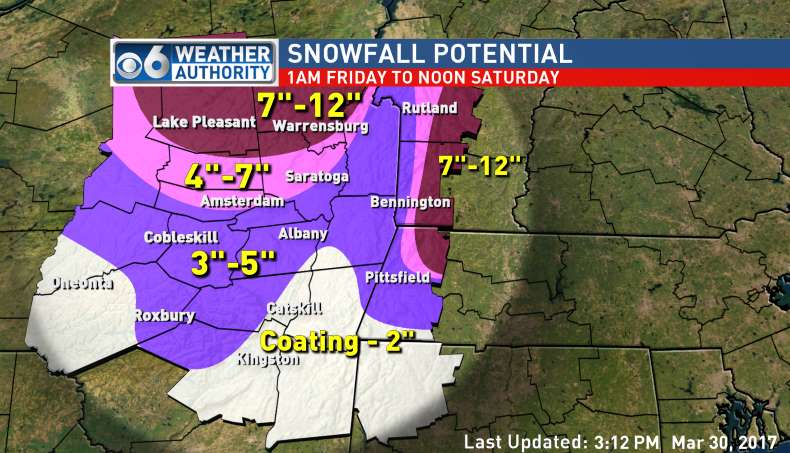 |
| Channel 6 Albany |
 |
| Channel 10 Albany |
 |
| National Weather Service Albany |
Really, it's just mess. The latest models are definitely leaning toward longer periods of sleet and freezing rain, which they were not indicating earlier in the week. The predicted temperature is still a moving target--some models show warmer and others have the cold air in place longer. This is just to say that we could see 1 inch or we could see 10 inches. Elevation and north/south location will make a big difference tomorrow.
Despite the uncertainty, this is what the GSD Staff thinks is going to happen. It will be snowing or sleeting during decision time for Superintendents tomorrow morning, especially north of I-90. Most will choose to go with a full school day because the roads won't be too bad. Because of the threat for ice and power outages, one or two will get nervous and opt for the snow day. The likely candidates are North County schools as well as Central Berkshire, due to the higher elevation. Then, if we get an extended period of sleet and freezing rain, we could see some schools call the early release and let the youngsters get a head start on their weekend. Schools south of I-90 are probably going to have a full day, with a slight chance of a delay.
The Staff will be up early. We'll update on the storm and run a list, should schools opt out tomorrow.
Winter Weather Advisory for Northern Berkshire
The NWS has just changed the Winter Storm Watch to a Winter Weather Advisory. Under normal circumstances we would consider this a downgrade and our chance for a snow day would also be downgraded, but nothing about this storm is typical.
The forecast now is for 4-7 inches of snow but--as we feared might happen earlier in the day--the storm is now scheduled to start a few hours earlier. The Winter Weather Advisory begins at 2 AM, which means it could be snowing and/or sleeting right in the wheelhouse hours of 4-5 AM.
So...we're going to alter the True North Confidence Meter only slightly. North County schools have a better chance for a snow day now due to the improved timing, but not by that much. South County schools still look like they'll be left out as the snow fall total likely won't be high enough to warrant snow days.
Because of the very long time period of this system--all the way through Saturday afternoon--it doesn't seem as if it will be snowing hard enough in a short enough period of time to make the roads supes dangerous. But that's merely speculation on our part as this storm is proving to be very hard to nail down even 12 hours in advance of it.
We'll be out of commission for a few hours this evening, but we will be back around 9 PM for our final update of the day.
The forecast now is for 4-7 inches of snow but--as we feared might happen earlier in the day--the storm is now scheduled to start a few hours earlier. The Winter Weather Advisory begins at 2 AM, which means it could be snowing and/or sleeting right in the wheelhouse hours of 4-5 AM.
 |
| A slight upgrade from earlier in the day. Image courtesy of the NWS. |
 |
| Looks about right. Thanks to WNYT Channel 13 for this image. |
We'll be out of commission for a few hours this evening, but we will be back around 9 PM for our final update of the day.
Don't Let It Fool You
For ease of use, we'll call this the April Fool's Day storm. And it does appear to have some trickery up its sleeve.
More signs are pointing toward a full school day or an early release tomorrow for the northern half of Berkshire County. We've had no movement on the Watch to a Warning, and Advisories have not yet been posted for South County. That could all change this afternoon and evening, though, so don't set anything in stone just yet.
The latest run of the models indicates the brunt of the storm will hit just to our north, northwest, and east. The Weather Channel's map appears to be very aggressive, calling for over a foot for our neighbors in Franklin and Hampshire County. We'll be surprised if we see totals that high.
But just the fact that there's such widespread difference in the predicted snow fall totals means that we can't sleep on this storm. Given the winter we've had, it would not be wise to underestimate this storm's potential. The moisture will be there. It all comes down to how long it stays as snow.
The GSD Staff unanimously agrees that school will be in session tomorrow. If this were the first storm of the season, we would probably see full snow days because of (1) the novelty of it and (2) there's house money to play with when you haven't used up any snow days yet. But because the end of the school year is hastily approaching July 1, Supers will be quick to pump the brakes on a snow day for tomorrow. The early release, however, is very much in play for North Berkshire schools as conditions should deteriorate as the day progresses...as long as it stays all snow.
The big stumbling block for our staff is the temperature. We will get close to 32 degrees tonight but not beneath it. Snow can still fall when the temperature is above freezing, but often it takes a while to stick to the roads in those situations. Roads should be passable tomorrow morning unless the storm suddenly speeds up and the snow starts falling around 4 AM instead of 6 AM. We'll have to wait until later to know exactly when the snow should start to fall.
We stay informed to keep you informed!
More signs are pointing toward a full school day or an early release tomorrow for the northern half of Berkshire County. We've had no movement on the Watch to a Warning, and Advisories have not yet been posted for South County. That could all change this afternoon and evening, though, so don't set anything in stone just yet.
 |
| A bold call from The Weather Channel. |
But just the fact that there's such widespread difference in the predicted snow fall totals means that we can't sleep on this storm. Given the winter we've had, it would not be wise to underestimate this storm's potential. The moisture will be there. It all comes down to how long it stays as snow.
 |
| One of our favorite maps: the NOAA Probabilistic Snowfall Map. |
The GSD Staff unanimously agrees that school will be in session tomorrow. If this were the first storm of the season, we would probably see full snow days because of (1) the novelty of it and (2) there's house money to play with when you haven't used up any snow days yet. But because the end of the school year is hastily approaching July 1, Supers will be quick to pump the brakes on a snow day for tomorrow. The early release, however, is very much in play for North Berkshire schools as conditions should deteriorate as the day progresses...as long as it stays all snow.
The big stumbling block for our staff is the temperature. We will get close to 32 degrees tonight but not beneath it. Snow can still fall when the temperature is above freezing, but often it takes a while to stick to the roads in those situations. Roads should be passable tomorrow morning unless the storm suddenly speeds up and the snow starts falling around 4 AM instead of 6 AM. We'll have to wait until later to know exactly when the snow should start to fall.
We stay informed to keep you informed!
April Fool's Eve Snow Storm -- Morning Report
We have a few tidbits for you this morning as you prepare for snow day 7, 8 or 9 for your school.
*The timing of the storm is now not as good as we thought it would be a few days ago. It's still very good, but it looks like the snow will start for the Berkshires between 6 and 7 AM. So, this means Superintendents are going to have to make their decision based on the forecasted snow and anticipated driving conditions, which is never an ideal scenario.
*It will snow and sleet throughout the day for Northern Berkshire county, but we'll see a changeover to rain south of I-90. Higher elevation towns will see snow all day with a lesser chance of sleet mixing in.
*Snow-to-liquid ratios will be low for this storm. The snow will be a nightmare to shovel if it accumulates over 6 inches.
*The period of heaviest snow is expected to be in the early evening on Friday. Snow will last until the earliest hours of Saturday.
Right now we think snow days and early releases are in play. Delays seem unlikely given the 6 AM start to the storm. We could see some schools making the call to go with an early release tomorrow morning as the morning drive will likely not be as bad as it potentially could be in the afternoon.
The words we are consistently seeing from our weather sources are "low confidence." There are so many moving parts--the timing, the intensity of the late March sun, the rates of expected precipitation--that it will be hard to predict the final outcome. The warm late March sun makes a changeover likely, but if the precipitation comes down hard enough, that will pull cool air in and prolong our period of snow tomorrow and tomorrow night.
You can see why this will have to be a "game day decision." No Superintendent will make his or her call tonight--of that you can be assured.
We do have a few maps to share, with more to come later.
Of course we'll have much more later today as we start to see a few more runs of the models.
*The timing of the storm is now not as good as we thought it would be a few days ago. It's still very good, but it looks like the snow will start for the Berkshires between 6 and 7 AM. So, this means Superintendents are going to have to make their decision based on the forecasted snow and anticipated driving conditions, which is never an ideal scenario.
*It will snow and sleet throughout the day for Northern Berkshire county, but we'll see a changeover to rain south of I-90. Higher elevation towns will see snow all day with a lesser chance of sleet mixing in.
*Snow-to-liquid ratios will be low for this storm. The snow will be a nightmare to shovel if it accumulates over 6 inches.
*The period of heaviest snow is expected to be in the early evening on Friday. Snow will last until the earliest hours of Saturday.
Right now we think snow days and early releases are in play. Delays seem unlikely given the 6 AM start to the storm. We could see some schools making the call to go with an early release tomorrow morning as the morning drive will likely not be as bad as it potentially could be in the afternoon.
The words we are consistently seeing from our weather sources are "low confidence." There are so many moving parts--the timing, the intensity of the late March sun, the rates of expected precipitation--that it will be hard to predict the final outcome. The warm late March sun makes a changeover likely, but if the precipitation comes down hard enough, that will pull cool air in and prolong our period of snow tomorrow and tomorrow night.
You can see why this will have to be a "game day decision." No Superintendent will make his or her call tonight--of that you can be assured.
We do have a few maps to share, with more to come later.
 |
| From NBC Channel 22 in Springfield. |
 |
| From the National Weather Service in Albany. |
Wednesday, March 29, 2017
Winter Storm Watch for Friday for Northern Berkshire County
We don't suggest you go into full freak out mode just yet, but the National Weather Service just dropped a Winter Storm Watch on Northern Berkshire County. Nothing has been posted for Southern Berkshire County yet, but we see a Winter Weather Advisory in your near future.
The Watch is up because the potential for 5-10 inches of snow exists. Because Northern Berkshire is the southernmost area of the watch, this likely means that we'll be on the low end of the 5-10 inch prediction. Also, the Watch begins at 5 AM and ends at 11 AM on Saturday.
We do want to remind you that a Watch does not mean a snow storm will definitely happen. We will raise the True North Confidence Meter up a few ticks in response to the Watch, but things will get real only if the Watch gets bumped up to a Winter Storm Warning. If that happens, students in several schools will not have classes on Friday.
Perhaps it's a sign--perhaps it isn't--but 20 years ago on these exact dates New England got pounded by a major snow storm. Here's a map from the 1997 storm on March 31 and April 1, courtesy of Boston meteorologist David Epstein.

We really doubt we'll reach snow totals that high, but it is a nor'easter and there may just be enough cold air in place to give us moderate to heavy snowfall throughout the day on Friday.
Twelfth graders--and sixth graders--rejoice.
Snow For Friday
Just when it seemed we had turned the corner--whammo!--winter is back. Or so we think.
According to our sources of information, it looks like snow will fall in the Berkshires starting late on Thursday night. Yes, the morning commute could be impacted.
As of this morning, we're seeing a wide range of possibilities for snow outcomes. At the low end, we would see a coating of heavy wet, slushy snow in lower elevations with a transition to rain by midmorning. In higher elevations, the snow would hold on for longer, leading to 2-4 inch snow totals, before the rain kicks in in the afternoon. Given this outlook, we might have a delay or two in the usual locations (Florida, Central Berkshire, Southern Berkshire).
On the high end, we could see 4-6 inches in the lower elevations and 8-12 in the hill towns. Given this outlook, we would see--[deep sigh]--cancellations.
Those of you who want to get on with spring, take comfort that there are many moving parts with this storm and it could all turn to rain. Keep those fingers crossed.
Those of you who want a snow day--pretty much 12th graders and that's it--you've been on a hot streak this winter, so why won't that continue?
The GSD Staff is at the ready; we'll have much more later today.
According to our sources of information, it looks like snow will fall in the Berkshires starting late on Thursday night. Yes, the morning commute could be impacted.
As of this morning, we're seeing a wide range of possibilities for snow outcomes. At the low end, we would see a coating of heavy wet, slushy snow in lower elevations with a transition to rain by midmorning. In higher elevations, the snow would hold on for longer, leading to 2-4 inch snow totals, before the rain kicks in in the afternoon. Given this outlook, we might have a delay or two in the usual locations (Florida, Central Berkshire, Southern Berkshire).
 |
| From the NWS--not too bad so far. But this map will be updated. |
Those of you who want to get on with spring, take comfort that there are many moving parts with this storm and it could all turn to rain. Keep those fingers crossed.
Those of you who want a snow day--pretty much 12th graders and that's it--you've been on a hot streak this winter, so why won't that continue?
The GSD Staff is at the ready; we'll have much more later today.
Sunday, March 26, 2017
Freezing Rain for Sunday Night
If you're out and about tonight (Sunday), be aware of the potential for freezing rain. We won't see steady rain tonight, but a few showers could slide through the Berkshires and create the potential for slightly hazardous driving conditions.
We know what some of you are thinking, and we need to squelch those ideas right now. There's no chance for the freezing rain to impact the commute to school tomorrow morning. As the rain moves through, temps will be on the rise. We may even hit 60 by Tuesday.
With daytime temperatures in the 40s and 50s all week, we could be seeing the end of winter. Expect rain on Monday and Tuesday and then dry days for Wednesday and Thursday. Friday is up in the air, as the professional weather prognosticators have forecasted a rain/snow mix.
Spring sports teams hoping to get on fields this week will likely have to wait another week due to all the rain, but the snow should be all gone by Wednesday.
We'll be back later in the week to look at Friday's storm. We'll know more as the storm gets closer to us.
Thursday, March 23, 2017
Winter Weather Advisory for Friday
Old Man Winter still refuses to give up the ghost.
The old feller is relentless. While we don't think the forecast will impact the length of the school day on Friday, everyone should know that we could see some messy weather in the morning in the Berkshires tomorrow. We have been issued a Winter Weather Advisory by the National Weather Service.
Expect to see snow and sleet starting between 7 and 8 AM on Friday. The ride to school could be dicey--especially for the elementary school set--but the late (relatively) arrival of the snow will mean delays are highly unlikely. The ground could get coated quickly with the cold temperature in place. We might see an inch of snow and sleet north of Pittsfield and lesser amounts south of Pittsfield. All precipitation will change to rain after lunch.
After that little burst, you can expect to see showers and freezing rain from Saturday through Monday. The freezing rain on Monday morning is something worth keeping an eye on. This weekend will not help anyone who suffers from seasonal affective disorder. It looks like a great weekend to binge watch that show you've been meaning to get to.
We'll have more over the weekend. The worst driving tomorrow will between the hours of 8:30 and 11:00.
Thursday, March 16, 2017
More Snow for Saturday
Now that we've had a day to dig out, we have a few observations on the most recent storm.
Forecasters definitely hit it right on the nose for Berkshire County, but they whiffed on their prediction for NYC and Boston. We almost had another Trump/Hillary, Pats/Falcons, Moonlight/La La Land scenario on our hands. We heard of one teacher in Berkshire County who promised he would give students 100s on their most recent quizzes AND staple $100 to their quizzes if there was no snow day on Tuesday. He came a lot closer to making his students very happy than he probably realizes. The bust potential increased dramatically as the storm veered more westward.
The big winners were the Adirondacks and northern Vermont. Tuesday's storm dumped 30+ inches on Burlington, VT, making it the second biggest storm on record there.
In the wake of the storm, we've been left with some very cold January-like air. We won't get above freezing until Saturday afternoon when an Alberta Clipper comes a-visiting. This system should move on past us to the south, but parts of the County could see 2-4 inches by Sunday morning. Those in South County and in higher elevations have a better chance of needing the snow shovel again.
As for next week, temps will moderate and get into the 40s before the mid and low 20s return on Wednesday. Also, we're eyeing some kind of snow/mixed precipitation event for next weekend.
Happy first day of March Madness!
Forecasters definitely hit it right on the nose for Berkshire County, but they whiffed on their prediction for NYC and Boston. We almost had another Trump/Hillary, Pats/Falcons, Moonlight/La La Land scenario on our hands. We heard of one teacher in Berkshire County who promised he would give students 100s on their most recent quizzes AND staple $100 to their quizzes if there was no snow day on Tuesday. He came a lot closer to making his students very happy than he probably realizes. The bust potential increased dramatically as the storm veered more westward.
The big winners were the Adirondacks and northern Vermont. Tuesday's storm dumped 30+ inches on Burlington, VT, making it the second biggest storm on record there.
 |
| The forecasted precipitation for Saturday evening. A fifth of an inch of liquid--as seen here--will yield 2-3 inches of snow. |
As for next week, temps will moderate and get into the 40s before the mid and low 20s return on Wednesday. Also, we're eyeing some kind of snow/mixed precipitation event for next weekend.
Happy first day of March Madness!
Wednesday, March 15, 2017
Very Few Changes So Far...
Snow ceased falling around 1 AM, giving road crews plenty of time to get things under control. The only additions to last night's list are in blue below.
SNOW DAY:
Berkshire Christian School
Berkshire Country Day
Berkshire Hills
Clarksburg
Farmington River
Gabriel Abbott (Florida)
Lanesborough
North Adams
Richmond
Southern Berkshire
Southern Vermont College
TWO-HOUR DELAY:
Adams-Cheshire
BArT
Central Berkshire
Emma Miller (Savoy)
Hancock
Housatonic Academy
Lenox
McCann
MCLA
Mohawk Trail
Mount Greylock
Pine Cobble
Pittsfield
Southwest Vermont Supervisory Union
Stamford (VT)
Williamstown
THREE-HOUR DELAY:
New Lebanon
Berkshire Community College
OPENING AT 11:00
Williams College (Admin Offices; Children's Center at 10:30)
Subscribe to:
Posts (Atom)