Friday, December 23, 2022

Closings for Friday, December 23

Yes, we do have one lucky group of students today who have the day off. Some schools in New York are closing early, and many schools in eastern Mass have the day off due to the high winds and flooding potential. 

For the rest of us, drive safely in your travels today. Watch out for steeply falling temperatures and "flash freeze" conditions. The cold air should begin to push through the Berkshires around 4:00. 

CLOSED:

Farmington River

Stamford (VT)

Thursday, December 22, 2022

Winter Weather Advisory for Northern Berkshire: Thursday/Friday Dec. 22/23

NWS Albany has announced a Winter Weather Advisory with up to 6" of snow possible for Northern Berkshire County this evening.


It appears as if enough cold air will be in place, especially in high elevation towns, for some of us to see accumulating snow for several hours before everything changes to rain and high winds.

So, due to this new development, we may see a smattering of full snow days. Most likely candidates would be the high elevation elementary schools (Abbott, Miller, Clarksburg) on the east side of the county. Delays are less likely on Friday because most schools have a shortened day anyway. Because any snow will transition to heavy rain, even in the higher elevations, roads will most likely be wet and not snowy during the Friday morning bus runs.

The craziest thing that we will see on Friday--aside from the high winds, heavy run, and flooding--will be the rapid drop in temperature. In Cheyenne, Wyoming yesterday, the temperature dropped 42 degrees in 60 minutes! We don't think the fall will be that abrupt here, but we will see a 40+ degree temperature drop in about 12 hours. At the GSD Home Office in Williamstown, we are expected to move from a high of 50 midday on Friday to a low of 8 in the wee hours of Saturday morning.

Buckle in, as the next 36 hours are going to be lively.

Wednesday, December 21, 2022

Huge Rain Storm Friday; Blizzard For The Midwest

Happy Holidays, faithful Flake Followers!

With only two more wake-ups until a glorious week of vacation, the weather gods are conspiring against us New Englanders. We will be on the wrong side--the warmer east side--of a monstrous storm that is going to really foul up people's travel plans on Friday.

An enormous bulge of cold air has already started to push its way into central US states. A snow storm will break out on the east edge of the bulge. Unfortunately, the cold air will not make to our area until the storm lifts past us to the northeast. While the upper Midwest will see snow and wind, we will only see rain and wind.

Check out those temps in Louisiana! This map is for midday on Friday.

Meteorologists are forecasting A LOT of rain for our area starting on Thursday and carrying into Friday. In some ways, the duration of this end-of-week storm will be similar to last week's storm. Precipitation could linger into Saturday.

There is a chance the initial burst of precipitation will fall as snow, but the snow will change to heavy rain shortly thereafter. Still, there are two big concerns: 1) the wind; 2) flash freezing on Friday afternoon.

Winds Friday morning could hit 60 mph. Power outages are not only possible but likely. And then Friday afternoon and night we will see a 30-degree drop in temperatures. We will go from the 40s in the day on Friday to low teens by early Saturday morning. With over 2" of rain expected Thursday night and Friday, that could create treacherous driving conditions Friday night if roads are not treated.

Even though it's not a snowmaker, this storm could very well impact your plans given the size and duration of the event. Indoor activities are greatly encouraged for Friday, and you'll need to bundle up if you head out on Saturday as temps will not break 20 that day. Christmas Day is looking dry but still cold, with temps eventually getting into the low 20s after a very cold start--single digits for most.

We're definitely keeping an eye on this very volatile storm. We should be able to get one more report out on Thursday before we take the weekend off for the holiday.

Friday, December 16, 2022

Friday Nor'easter: An Early Postmortem

Look, we got what we asked for, but for many of us it feels kind of cheap, doesn't it? 

Most locations under 1000 or 1100 feet simply have not seen the snow that was forecasted to fall. That warm air would not budge, as we feared, and it's been a mostly rain event for the western and central portions of the County. But the storm did absolutely deliver--and continues to do so--in the hill towns.

Snow reports as of 3 PM, Friday.

We're not out of the woods just yet. There's plenty of moisture in the air, and we are supposed to see heavy snow bands come through Berkshire County this afternoon and this evening. We don't suggest you hold your breath on those promises, but hopefully we'll at least replace the snow cover we had in place before this storm.

The 3:15 PM radar. 

After today's storm moves out, we will have a period of tranquility until the next storm threatens us Thursday/Friday (22nd-23rd). Sunday through Wednesday will be calm winter days with temps right around freezing and more sun than clouds. 

Your weather app may be showing a big storm for Thursday/Friday--and the weather Twitterati were all over this pre-Christmas storm a few days ago--but we have reason to believe it could miss us. Our skepticism has less to do with today's bust of a storm and more to do with what our man Bernie Rayno of Accuweather is saying. He thinks the storm is going to cut in to our west, and when Bernie speaks, we listen. We still might be on the outdoor edge of the storm, which would mean light snow for us, but the big winners will be in the Ohio valley, Pennsylvania, and western New York.

There's A LOT of time left for the track of the storm to change. It really would be nice for the Christmas holiday if we could get a fresh covering of 6" on the 23rd. But at this moment that's more of a wish-cast than a forecast.

Enjoy the weekend and we'll have more to say about the upcoming storm in a few days.

Thursday, December 15, 2022

Friday Nor'easter: Final Update

CLICK HERE FOR SNOW DAYS AND DELAYS.

Snow has started to fall in southern Berkshire County. Yes, the temperature is still high (37 at the GSD Home Office as of 5:30 PM), but as the snow falls, it will suck cold air down to the surface and temps will settle in right around freezing.

The good news is the most recent runs of the models have ticked expected snow totals up a few inches. According to NWS Albany, Pittsfield is now slated to get 11", Savoy 21" (!), and that worrisome southeast corner (Sheffield) now shows 6-8" inches. It appears those those Instagram prayers were successful. (If you don't follow us on Instagram, get in on the action -- @greylock_snow_day.)

Funnier things have happened--and can still happen due to the close call with the temperatures--but we are fairly confident that most students in the County will have a snow day. A few predictable schools have called in their snow days (northwestern elementary schools), and Williams and MCLA have weighed in as well. Go here to see the latest schools on the list.


One other aspect of this storm that we haven't addressed is the heaviness of the snow. Snow to liquid ratios could be as low as 7:1. Most storms come in at 10-12 inches per 1 inch of liquid. We are supposed to see 2+ inches of liquid with this storm, so that's why snow totals are so high. Area physical therapists are going to be busy next week!

We're hoping the major school districts will make their decision tonight, but, of course, they are not obligated to do so. We think almost everyone will have a snow day tomorrow, but some of you will have to set the alarm to find out.

And here are some more maps!


December 16: Closings and Delays

A few schools and colleges have announced their plans for tomorrow. Here is what we know so far (LAST UPDATE: Thurs. Dec. 15 11:26).

SNOW DAY:

Adams-Cheshire\
BART
BCC
Berkshire Hills
Berkshire Waldorf
Central Berkshire
Clarksburg Elementary
Emma Miller Memorial
Farmington River
Gabriel Abbott Memorial
Hancock
Lee
Lenox
MCLA
Mount Greylock (including LES and WES)
Mohawk Trail
North Adams
Pine Cobble
Pittsfield
Richmond
Rowe
Southern Berkshire
Southwest Vermont SU
Stamford (VT) Elementary

TWO-HOUR DELAY:

Williams College Administration Offices -- Final Exams are still on as scheduled!

Friday Nor'easter: It's Snow Time!

Just a few hours now until the first flakes will be a-flyin'. The radar would indicate that snow is practically on our doorstep, but the storm is running into a wall of cold air, which will keep the snow at bay for several more hours. NWS Albany is saying that snow will begin around 8 PM, but we won't be surprised if it starts an hour or so earlier.


The best news we can give right now is that a Winter Storm Warning is up for the entire county as well as Litchfield County in northwestern Connecticut. Why is the Litchfield County info important? It means that meteorologists think the cold air will be more firmly entrenched, which means a longer initial period of snow for this storm.

The basic contour of this storm is as thus: Snow tonight with some heavy bands after midnight. Possible changeover to rain in locations below 1000'. All snow still above 1000'. Toward the evening a return to all snow for even the valley locations, with an additional 2-4" expected by Saturday morning. We expect 4-8" on the western edge of the county and 8-12" on the east side. The highest locations in the county should see between 14-18" (Savoy, Hinsdale, Florida Mountain).

The two big factors that should give most students the full snow day are 1) the timing; 2) the threat of snow throughout the day on Friday. Even if there is a changeover to rain, it's going to be very hard for any rational Superintendent to send students out into the elements. Also, a sneaky third factor will be the wind. Gusts of up to 45 miles per hour will make for even more treacherous conditions during the day on Friday. 

From NWS Boston.

So, we are going to bump up the meter slightly to reflect the wind factor, which we had not considered yesterday or earlier in the week.

Besides the snow/rain changeover, the big question mark is will Superintendents make the call at the end of the school day, the early evening, or tomorrow morning. 


Wednesday, December 14, 2022

Friday Nor'Easter: T-Minus 24 Hours

It is not our style to pull back the curtain and divulge the particulars of GSD Staff meetings, but boy, oh, boy was this afternoon's meeting a doozy! Let's just say my hands are still shaking as we nearly came to blows. 

To put it mildly, there's some disagreement about what the heck is going to happen on Friday. While we--actually I, as the chief coms guy of this operation--pride ourselves on the consistency of our messaging about snow days, this mid-December Miller B nor'easter has divided the office. We think the division will be reparable, but right now there's not a lot of warm and fuzzy banter in the break room.

But enough of that. You came here for solid snow day info. And here's what we got: 

While most indicators would suggest we will have widespread snow days and delays for everyone in the county (yes!), the data we're seeing about air temperature is deeply concerning (no!). A good majority of the staff thinks that the models are over-inflating the temperatures and tonight's radiational cooling plus the heavy rate of snowfall (once it starts) will suppress temperatures and give the whole county a plowable snow event. 

But there's a loud and veteran faction on the staff who think the warm air--temps will be above freezing at the start of the storm tomorrow night--is going to suppress snow totals drastically. And with some models predicting temperatures into the mid and even upper 30s during the day on Friday, they think this storm has major bust potential.


So, we're going to hold the Confidence Meter right where it is for now.* We love the fact that we're seeing eye-popping snow total projections for the eastern half of the county. Florida, Savoy, Hoosac Valley, Central Berkshire--you should all be safe and have a snow day as the elevation in your district means buses will have a devil of a time on Friday morning. Those schools more toward the east and in lower elevations--North Adams, Mount Greylock, Pittsfield, Lee, Lenox, Berkshire Hills, Southern Berkshire--it's going to be touch and go. At the very least delays are highly likely, but if we see the changeover to rain in that 4-5 AM slot, then Superintendents are going to have a much harder decision.

We know most of you would like to know if any Superintendents will call the snow day tomorrow, either at the end of school or on Thursday night. A few schools and districts will have that luxury--our northwestern elementary schools and Central Berkshire, most likely--but most will not. Perhaps they will surprise that, but that's gut feeling tonight.

Again, we should underscore that things are looking very favorable, but there's a big "but" looming out there in the form of dreaded warm air. The last thing we want to do is get your hopes up only to see them obliterated on Friday morning when you are staring in the bathroom mirror brushing your teeth and asking yourself, "Why am I going to school today?"

Nice map, WNYT, Channel 13 in Albany. And Snow Map-alooza--coming tomorrow!

*A reminder about percentages on the Meter. The percentage is combination of two projections: 1) The chance any student in Berkshire County has of getting a delay, snow day, or release; and 2) The percentage of schools in the County to have a delay, snow day, or release. So, a 15% chance of a snow day means that you have a 15% chance of being in a school that will have a snow day because we think 15% of schools in Berkshire County will have a snow day.


Friday, December 16 Storm Update -- T-minus 36 Hours

Expectations for this messy storm are starting to come into better focus, but there is still a high degree of uncertainty about what is going to happen in South County. 


We're going to need a few questions answered in the next 24 hours:

*Will the Watch get upgraded to a Warning for Northern Berkshire? If that happens, then students from Pittsfield and Central Berkshire and all districts north will have snow days on Fridays.

*Will the expected snow totals continue to go up? NWS Albany adjusted their maps in the wee hours this morning to reflect higher snow totals. That's a great trend.

*Will South County get a Winter Weather Advisory or a full Winter Storm Warning? If NWS Albany goes with an Advisory, then delays--not snow days--are still in play, especially for Southern Berkshire, Farmington River and maybe even Berkshire Hills. If the Warning gets announced, then full snow days are almost assured for all.

*Will we get radiational cooling this evening? The lower the temperature drop this evening, the more entrenched the cold air will be. More cold air, longer period of snow. Even just a few additional hours of snow before the shift to rain (South County) could make a big difference between getting a delay and getting a snow day.

*Could this storm be a bust? There's a lot of moisture with this one, but that threat of warm up pushing up the Hudson Valley and into western Berkshire County is definitely a possible scenario. It would be by far the cruelest outcome, and it's definitely in play.

At this point, just under 36 hours away from the start of the storm, we have high confidence that Northern Berkshire schools will have full snow days and South County schools will have--at the very least--delays. The timing is perfect as is the threat of severe weather throughout the day on Friday. Those two factors alone will give Superintendents pause as they consider making their staff and students travel to school.


Tuesday, December 13, 2022

Will You Have School On Friday, December 16?

In the immortal words of Professor Hinkle: "Messy, messy, messy!"

We have a really interesting and complicated storm setting up for Friday. This Miller B is proving to be difficult. We truly wish there was more certainty at this point--as do the meteorologists in our region--but this one is going to very hard to predict. And chances are good that the prediction is not what actually happens.

The semi-good news is that we have a Winter Storm Watch up for Northern Berkshire County. This means the potential for 7+ inches of snow exists. And the timing could not be better--7 PM Thursday through Saturday morning.

The bad news is that warm air is going to play a big role with this storm and could creep far enough north to make this a snow-to-rain event for everyone in Berkshire County. We are seeing some models that are keeping the cold air in place longer, which means all snow even in the valleys. Other models show a nose of warmer air pushing up from the Hudson Valley and extending into the southern and western portion of the County.

The initial NWS-Albany features a blend of these models, and--if it's accurate--we'll see several districts call snow days for Friday.

Quite the spread of snow totals for the County. 

Given the timing and the threat for high snow amounts, as long as it's snowing between 5 and 6 AM,  many districts will go with the snow day. If the conversion to rain has occurred at that hour, then we could see delays for several districts. Either way, the consensus of the GSD Staff is that most students in Berkshire County will have a delay or full snow day on Friday.

As we get within 48 hours of a storm, one model that meteorologists like to use is called the NAM. It stands for North American Mesoscale, but it's a different model than the other North American model we always talk about in relation to the Euro model. The NAM is a better regional model because it takes into account small-scale weather phenomena. (How it does that is above our pay grade.) So let us check in with the NAM tomorrow and we should have a better read on what the storm should do.

We would like to see two things happen: 1) We want to see the Winter Storm Watch extended to South County. 2) We want to see those Watches upgraded to Warnings. If that happens on Wednesday or early Thursday, then enjoy your three-day weekend.

Monday, December 12, 2022

Nor'easter School Is In Sesson

We love when a storm over performs, and yesterday's clipper-type system certainly did that. Here are snow reports from around the region. We did much better in mid-County and South County than we thought we would do.

Now, all talk will shift to the potential blockbuster of a storm for the end of the week. Not surprisingly, there's some uncertainty about the track and timing, so unfortunately we can not "lock this one in" just yet.

Before we get into this storm's particulars, you may hear chatter about the end-of-the-week storm as a  "Miller B storm." What does this mean? Who is Miller? Is there a Miller A storm?

Image courtesy of the National Weather Service.

Your GSD Nor'easter Seminar is now in session. "Miller" is meteorologist J.E. Miller, who identified two types of nor'easters in 1946. The first--type A--originates in the Gulf of Mexico, shoots across the coastal southeast states, and then gains energy along the coast of the mid-Atlantic states and New England. The second type--type B--comes out of the Ohio River valley, travels to the east coast, then picks up energy there and starts to move along the coast in a northeasterly direction. When the type B hits the coast and starts to move up, that's when you hear the terms "cyclogenesis" and "bombogenesis" as the storm picks up in strength and intensity.

The end-of-the-week storm will be a Miller B storm. That is exciting, as it could dump as much as a foot of snow on the Berkshires. Both the Euro and North American models are showing significant snowfall for most of the Berkshires by midday on Saturday. There's too much uncertainty right now to even hazard a guess for Friday, but let's just say we won't be surprised if there's serious discussion in a few days about a potential snow day and three-day weekend. 

We'll start to see more certainty about the future behavior of this storm by Wednesday morning. We're monitoring it around the clock and hope to have good news to share very soon.

The North American model for snow totals by 6 AM Saturday. The NA model takes the storm farther south and east.

The Euro model for snow totals by midnight Friday. The dry slot south Albany is concerning, but the rest looks great.

Delays for Monday, December 12

So far, road crews have put in good work and cleaned up the streets. Most schools appear to be in full session. Here's what we have so far (last update 6:53 AM): 

TWO-HOUR DELAY:

BART

Berkshire Community College

Hancock

Hillcrest Academy

Mount Greylock Regional 

Pine Cobble

Pittsfield

Berlin

New Lebanon

Southwest Vermont Supervisory Union (Mt. Anthony)

Sunday, December 11, 2022

Sunday Clipper Update

Just a quick update. We know many of you are very eager for the first delay or snow day of the year, but it's probably not going to be this storm. We'll get 3-4 inches in most locations, with slightly higher amounts for the eastern hill towns.

The problem for delays tomorrow (Monday) is twofold. One is that much of the snow is melting on the road. Two is the timing of the end of the snow. It's still slated to end around 1 AM. Maybe a generous superintendent will throw you a bone and allow a little time to clean off the car, but we wouldn't count on it.

Not encouraging.

And although it doesn't have to do with snow, there's A LOT of sickness in schools these days. The flu is doing its best Covid impersonation. While we did hear rumors that some elementary schools in the area shut down recently due to a high number of sick teachers, it's possible some schools could close for a day or two this week due to widespread illnesses. It's not clear what one or two days off will do to reduce the spread of the flu bug, but it's possibly a strategy school officials might employ before our next vacation. We'll just have to see about that.

We don't have much new to report about the bigger Friday storm. Models will start to move toward agreement Tuesday and Wednesday.

Saturday, December 10, 2022

Winter Weather Advisory for Sunday; More Storms on the Way

Ten days from now, the Berkshires will likely have a very different look. The GSD Staff is eyeing not one, not two, but three chances for measurable snow in the next 10 days.

First up is the appetizer. The clipper we wrote about earlier in the week is on its way. Yay for snow but boo for timing. Snow will descend upon us in the afternoon and evening tomorrow (Sunday). Even though we have a Winter Weather Advisory for the Berkshires tomorrow (for 3-5" of snow),  road crews will have ample time to get the roads clear for the bus runs on Monday morning. The expectation is that snow will start in the early afternoon and wrap up shortly after midnight. We can't rule out a delay or two for some towns, but most students will have a full day of school on Monday.

Not bad for a clipper system.

Then things get interesting. Some models are showing a nor'easter for Friday/Friday night. It's much too early to lock this one in, of course, but the potential certainly exists for a moderate to heavy snowfall. Even though the storm center will emerge from the southeast, there's a piece of energy coming in from the Northwest that will determine if we get snow on Friday. If that northwestern energy is too strong, it would push the storm south of us. If it dissipates, we'll get the first big one of the season. Say a little prayer for the Euro model (see below) as that is the one that is showing a more significant storm.

Euro model for next Friday/Friday night. This will change so don't get TOO excited.

And finally in the week before Christmas we're looking at another moderate storm potential. Simply put, we are in a great pattern. Should that storm come to fruition, we're looking at a Tuesday/Wednesday event (Dec. 20-21).

With only 10 days of school until the next vacation, we think chances are high that we will have at least one snow day. Right now we would put the chances of at least one snow day at 60% and the chances for two snow days at 20%. 

We're excited about the 2-3" we'll get tomorrow, but it's the Friday storm that has most of our attention. We look forward to providing frequent updates about it in the upcoming week.

Wednesday, December 7, 2022

Snow For The Monday Commute?

Maybe, just maybe, things are starting to pick up for all of us snow lovers in the Berkshires. With our collective GSD ears to the ground, we are picking up rumblings about a potential messy commute on Monday.

Despite a VERY balmy day today (Wednesday), temps will begin to drop as we move toward the weekend. The Thursday through Saturday period should be relatively dry. But on Sunday a storm system will move in from the Great Lakes. This clipper system should be able to pick up some additional Atlantic moisture and generate a swath of precipitation for our region.

If there is enough cold air in place, we could see a few inches of snow right on into the morning commute on Monday. The North American model is showing 3-4 inches for the Berkshires, while the Euro only shows an inch or so. These models will change, of course, but there is reason for some optimism here. The best outcome will be delays for most schools.

Probably too aggressive a forecast for Monday, but one can only hope. (

As for a major whopper of a storm, we're not seeing anything taking shape for later next week. There will be plenty of moisture in the air, but it simply will be too warm for a prolonged period of snow.

Monday, December 5, 2022

A Whole Lotta Nothin'

Alas, the doldrums of December.

Despite the gradual build-up of holiday festiveness in the air, we are not seeing much on the short radar that would suggest any meteorological festiveness.

This week (Dec. 5-11) will be warm and wet early and then cooler by the weekend. After a dry Monday, we'll see a soaking rain during the day on Tuesday and well into Wednesday. Temps will be in the mid-50s so there's zero chance of any changeover even on the backside of the storm. By Thursday things will dry out as colder air comes into the Berkshires.

There's some debate about what's going to happen on Friday and the weekend. One model is showing a cooler, drier weekend. Other models point to rain and snow showers (Friday evening especially). We'll know more in a few days, but we're not expecting to get too excited over anything on the snow front.

There is some cause for optimism, though. We are starting to seem some encouraging forecasts for the Northeast for the middle of next week (Dec. 14-15, see below). The polar vortex is starting to shed some of its cold air, which could impact our area and set up a much more active snow pattern. And it's possible we could see that pattern continue right into the Christmas holiday. 

European model for snowfall by next Thursday. Models notoriously exaggerate snow totals this far out, but we'd take 50% accuracy, right?

There is a chance the second half of the month could make up for the poor start to December. Many more updates about the changing pattern will be coming later this week.


Saturday, November 26, 2022

Back From Thanksgiving Break: What To Expect

Happy Thanksgiving Weekend, Snowhounds!

After a little taste of winter last week, it's been quiet around the GSD Home Office with temperatures generally in the 40s for the last week or so. And, unfortunately, there's not much in the 10-day forecast to feast our eyes on. 

We'll see rain in the afternoon on Sunday, and then two dry days before a low pressure system comes up from the Gulf of Mexico to usher in the month of December. Normally, this type of storm would be something to get excited about, but it's going to track too far to the west. When we're on the east side of low pressure systems, too much warm air gets into the area and we get rain. There's no indication whatsoever that this storm will track further to the east and turn the rain to snow.

The European model for the Wednesday/Thursday storm. Not much to write home about.

As the storm departs, a cold front will come through, and that's when we could see a shift from rain to wintery mix or snow. This forecast is iffy, and the people with the best chance to see snow will be those who live in higher elevation towns. So snow is possible late Wednesday and early morning on Thursday but it won't be much.

The big noticeable attribute of the midweek storm will be high winds. We won't be surprised at all to see high wind warnings and alerts. Meteorologists are already talking about the potential for 50 mph gusts.

Enjoy the weekend!

Tuesday, November 15, 2022

The Chance For A Wednesday Delay Is Now Weaker

The good news: it's going to snow tonight. (In fact, it's snowing right now). Yay! The bad news: the storm is tracking more to our west than models and forecasters originally thought. Boo!

This means we will have our winter wonderland this evening so get out there and enjoy it. But a warm pocket of air is going to sneak up the from the south and change our snow over to mixed precipitation briefly and then all rain. Sadly, that changeover is going to happen much earlier than we thought: well before the morning commute.

So, it's not looking too great for delays. A few schools in higher elevation towns in the eastern part of the county could still get a delay, but most students should anticipate a full day tomorrow. We know that's not what you wanted to hear given all the stress and drama of the pre-sale today, but, like the Ticketmaster website, these early season storms can be very fickle and unreliable.

This ain't gonna cut it.

It's small consolation, but some of the models are showing impressive potential storms over Thanksgiving weekend and the middle of the week after Thanksgiving. And with the cold air in place for a few more weeks, our chance for an early season winter storm is still better than average.

Monday, November 14, 2022

Winter Weather Advisory for Tuesday Night and Wednesday; Delays Possible

Winter is coming in hot, so to speak, and the GSD Home Office is astir with activity. NWS Albany hoisted the Winter Weather Advisory flag earlier this afternoon, calling for 2-5" of snow for the Northern Berkshires and 1-3" for the Southern half.


Despite the relatively low snow totals for this storm, the timing is pretty delicious with a messy commute expected Wednesday morning. We're going to bump up the chance for a delay to 50% for two reasons. 1) The great timing. 2) Superintendents may want to kick the tires on the old delayed start system--get the admin team in place, dust off the numbers for DPW, and check to see if the district-wide robo-call works.

If you were to draw a diagonal line from Williamstown to Sandisfield, the schools on the east side of that line have a much better chance for a delay than those on the west side of that line. There may be exceptions, of course, but we'll see more snow and mixed precipitation in the north and east of our fair county.


There should be a changeover to rain later in the morning, so it's highly unlikely any districts will go with the full snow day on Wednesday.

We'll have more info tomorrow evening.


Sunday, November 13, 2022

Welcome To Winter, 2022-23! Delays Possible For Wednesday (Nov. 16)

Hello, fellow Flake Followers, Snow-a-holics, and Low Pressure System Lovers! We are back for another fun-filled winter in the Berkshires. Once again, we will be satisfying all of your snow day, delay, early release, and freeze day needs. With new technology and new GSD staff members, we are amped and ready to roll for the snow season.

And there's great news--snow is officially in the forecast this week. It's extremely late for us to get our first round of frozen precipitation--usually we at least see a flurry in late October--but the first snow this season could, in fact, be measurable. Delays are definitely in play for Wednesday! Right now we are expecting 1-3" for all of Berkshire County. Worse case scenario is an inch of wet snow on grassy areas and wet roads. Best case scenario is 3-4 inches with slushy roads that need to be cleared before school can start. We'll need some more information on just how cold it's going to get Tuesday night/early Wednesday morning before we settle in with a firmer prediction.

A promising mid-November forecast from NWS Albany. Delays possible for Wednesday.

Given how warm it's been, we think delays will be more the exception than the rule (25% chance), but we still have a 36 hours or so to modify the forecast. Stay posted for updates on this first winter weather producer. Eastern hill towns will have higher chances for delays.

Monday, April 18, 2022

The (Possible) Last Go-Around for 2021-22 -- Winter Weather Advisory for Tuesday, April 19th

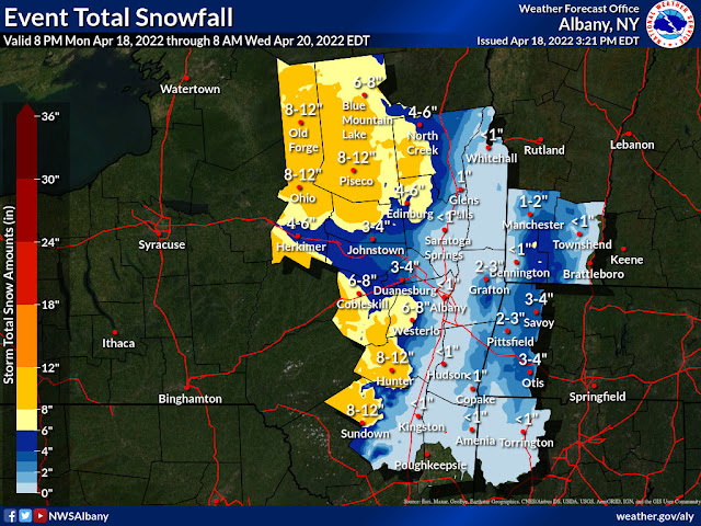
Yes, it's April vacation for most readers of these posts, but it's our meteorological responsibility to chime in on the potential for measurable snow this evening into Tuesday.

Yes, a Winter Weather Advisory is in effect for this evening and the early part of Tuesday for northern Berkshire County. Despite the mid-50s and sun we have enjoyed today, the approaching rain/snow from the southwest will drop our temperatures into the 30s tonight. That means wet snow for most of the county late tonight and into tomorrow.

Wet snow could accumulate in the valleys, but it will likely only coat the grass (1-2"). Some slush could show up on the roads, making for a slower commute for workers on Tuesday. But higher elevation towns (over 1500 feet) could see close to half a foot. Typically, the northeast towns of Berkshire County see higher snow totals for these late season storms.

Say it ain't so, NWS Albany...

Given the unpredictability of spring snow storms, we are not expecting widespread travel issues for Tuesday morning, but a few folks will need extra time to clean off cars in the morning. If snow does accumulate on the roads, it will be a wet, slushy snow and a little easier to drive on, as long as temps stay above freezing (which they should).

After the period of wet snow, it will be wet on Tuesday but temps will moderate. We'll be back up in the high 50s and low 60s by the end of the week and relatively dry.


Sunday, March 27, 2022

Snow Showers To Continue -- Delays Possible Monday (March 28)

It's going to look and feel like winter for a few days before a warm-up to more seasonable temperatures by the end of the week. Unfortunately, we're looking at another rain storm to close out March (Thursday into Friday morning).

Up here at the GSD Home Office in Williamstown, we've had snow showers on-again-off-again all day. (Sunday). Those snow showers will continue throughout afternoon, and they could intensify after midnight, creating accumulating snow.

Looks like our southern Vermont friends could even see snow days tomorrow.

It's a long, long shot, but there could be enough snow on the ground and in the streets to cause delays. There will be plenty of cold air in place for roads to get covered as most of us will see temps in the high teens Monday morning.

If the timing is just right and we get a particularly intense short period of snow, delays are possible. Higher elevation districts will once again have a better chance for the delay. They might see a repeat performance of Thursday up there in GAFEM country (that's Gabriel Abbott, Florida, and Emma Miller), and Hoosac Valley, Mount Greylock and Central Berkshire are also in the mix for delays.

Again, we want to stress that delays are not likely, nor will they be widespread. This is more of a wishful thinking event. But it would be a nice way to ease into the work week.

Whether some of us get a delay or not, Monday will be downright wintery. Highs in the 20s, windy, and occasional snow showers. Dress appropriately if you have practice outside after school.


Thursday, March 24, 2022

Delays for Thursday, May 24

Rain, sleet, and wind at the Greylock Snow Day home office this morning. Off and on rain is expected throughout the day and then picking back up again later tonight. 

We do have a few delays to report (last update: 6:12 AM):

TWO-HOUR DELAY:

Emma Miller

Florida

Gabriel Abbott

Wednesday, March 23, 2022

Winter Weather Advisory -- Will Anyone Get a Delay?

The cloud cover you saw this afternoon means rain is heading our way shortly around or after midnight. This rain, coupled with temps in the 30s, could lead to some snow and freezing rain in higher elevations.

It looks like the cut off for snow/freezing rain is at 1000 feet. If there are any delays at all--and, mind you, it's not a high probability occurrence--this means schools in the eastern part of Berkshire County have the better chance: Farmington River, Central Berkshire, Hoosac Valley, maybe even Mount Greylock.

NWS Albany

The thing we're interested in seeing play out is how cool it gets toward daybreak. This morning, temps were about 6° cooler than predicted at the GSD Home Office. If low temp predictions are just a few degrees off and you take into account that the rain will drag some of the colder air aloft downward and cool the surface, then enough icing is possible at the right time to push back the start to school.

Definitely, no one should count on a delay tomorrow, as current temps are in the high 40s (6 PM Wednesday). But there's a small chance that some of you out there will get to sleep in for a few extra hours. We'll post a list of those schools should there be any.

Tuesday, March 22, 2022

Winter Weather Advisory -- Delays Possible For Thursday (March 24)

NWS-Albany has issued a Winter Weather Advisory for Berkshire County for Wednesday night and the Thursday commute. This is your reminder that we're not quite out of the woods yet.

The combination of temps around freezing and an incoming rain storm could create icy conditions for the drive to school on Thursday morning. It looks like the east-facing slopes are the areas most likely to pick up more mixed precipitation, but all areas could see .10" of ice.

NWS Albany for Thursday morning.

Ice is really unpredictable. There's definitely a chance that superintendents will take the safe route and allow a few more hours for the buses to roll on Thursday morning. This will definitely be a Thursday morning decision once town road crews and bus companies assess the road. We think there will be at least a few districts that go with the delay, especially in eastern hill towns of the Berkshires.

Whether we get ice or all rain, Thursday is shaping up to be a cold (highs in the mid 40s) and wet day. The rain will lighter in the afternoon but then pick again overnight. Outdoor sports in the afternoon on Thursday will not be a lot of fun.

Icing will not be an issue Friday morning as the temps will be too warm.

Friday, March 11, 2022

Winter Storm Warning for Berkshire County (Saturday, March 12)

It's no Storm of the Century, but it looks like we have a sizable snow storm on our hands for a Saturday afternoon in mid-March.

The good news for snow lovers is that the entire county now has a Winter Storm Warning. Earlier today, NWS Albany split the middle with a Warning for Northern Berkshire and a Winter Weather Advisory for South County, but they wisely re-assessed their data and went with the Warning for the entire county. 

Still, those of you in Southern Berkshire County will get fewer inches of snow, but not that many. We expect to see 5-6 inches south of I-90 and 7-8 inches from Pittsfield and points north. It's also highly likely that we'll see double digit totals in the hill towns up by the Vermont border.

Here are the pertinent details:

*Rain starts before sunrise then changes over to snow between 8 and 10 AM.

*Snow comes down heavy at times. It will be wet and heavy snow early, but then as the temps drop, the snow will get lighter and fluffier and could really start to pile up in the afternoon.

*Snow should end between 6 and 8 PM.

*The wind will become fierce in the afternoon as well, with gusts approaching 40 MPH, which could create difficult white-out conditions.

And now some maps:

The blend of models map.

NWS Albany.

WNYT Channel 13 Albany.


Thursday, March 10, 2022

Winter Storm Watch for Saturday

Old Man Winter has found a second wind, and a second measurable storm for Saturday suggests the old goat's still got it.

NWS Albany has posted a Winter Storm Watch starting late Friday and ending late Saturday night. The Watch calls for the potential for 5 to 9 inches of snow for Western Mass. The heaviest snow will fall in the early afternoon on Saturday, and the potential for rates of 1-2 inches of snow per hour is the reason that the snow could pile up in a hurry.

NWS Albany is predicting a moderate snow storm.

Stop us if you've heard this before, but the uncertainty with this storm is the track. The Euro model pushes the track to the east, which means more cold air for us and more snow. The American model tracks the storm more to the west, and that means warmer air and a shorter interval for when we see all snow.

Right now our best guess for the Berkshires is 2-4 inches south of I-90 and 4-6 northward. Higher elevation towns up by the Vermont border could top out at 10 inches.

The Euro seems to be the preferred model for this storm as it's consistent with most meteorologists' predictions for Saturday.

The big thing we'll be watching is the track of the storm and the next announcement from NWS Albany. If we get the upgrade to the Winter Storm Warning, then get out the high boots. If the Watch becomes a Winter Weather Advisory, then we'll only see a few inches and the snow will all be melted by Tuesday.

Sunday could be one of the last days to get some sledding and nordic skiing in as there will be little melting that day with highs below freezing for the entire day. A big warm-up to the 50s is expected for every day next week, so this snow will not be around for long.

Wednesday, March 9, 2022

Winter's Back!

We have picked up a solid 3" of perfect snowball/snowperson snow (as of 4:30 PM) at the GSD Home Office in Williamstown, and the radar would indicate another half inch or so is still to fall.

Temps were slightly lower than expected at the onset, which allowed the snow to stick to roads quicker and create slick driving conditions.

The snow should end tonight by 8 PM at the latest, so that means, alas, that there's no chance for a delay or snow day on Thursday.

We know some of you out there begin to lose interest in more snow this time of year--and we can hardly blame you--but more snow is in the forecast for Saturday. The models are in agreement that it will snow this weekend, but there's significant spread in the forecasts. The American model shows another 3-4" snowfall for the Berkshires; the Euro is coming in hot with a 6-9" projection for our area. 

Loving the Euro forecast for Saturday. It's highly unlikely we'll get this much snow, but you never know with historically less predictable March storms.

Right now it would appear that the bulk of the snow will fall on Saturday in the afternoon and evening. Regardless of what happens around here, ski country to our north is going to get to extend its season if this storm does what it's supposed to do.

We'll have more detailed analysis for the weekend snow starting tomorrow.

Tuesday, March 8, 2022

Wednesday Snow

It won't be snowing on the way to school tomorrow, but it will be snowing on the way home. 

We are expecting 1-3 inches in Berkshire County on Wednesday, with chances for more snow in South County and in the east-facing slopes. Snow total predictions have been steadily rising over the past few days, so this minor storm does have some over-performance potential. Snow is expected to start between 10 and 12 AM.

NWS Albany.

Because there isn't very much cold air in place, the snow will initially melt on the roadways and sidewalks, but it will begin to accumulate on grassy surfaces. Eventually, probably for the evening commute home from traditional 9-5 offices, the roads will begin to get coated, so it could be slick out there for a few hours (4-8 PM).

It's certainly possible evening activities (i.e. high school basketball games) could be impacted/postponed.

And the snow for the weekend is still very intriguing. There's lots of chatter on weather social media about the possibility of a moderate snow storm once the changeover from rain occurs. More to follow.

Monday, March 7, 2022

Chances for Snow This Week (March 7-13)

It's been a few days since we've last written due to the end of vacation week and all the mild weather we've been experiencing. We definitely do no encourage you to put the shovels away just yet, but temps in the 60s sure felt nice on Sunday.

Winter, though, is still lurking out there somewhere, and we should see the Old Man make an appearance or two over the next few weeks.

First up is a chance for lake effect snow on Tuesday. A few flakes may make it all the way across New York state and coat the ground in the Berkshires, so don't be surprised to see a flurry or two.

Snow potential for Wednesday (European model). The American model keeps the snow well to our south.

On Wednesday, the northern fringe of a storm system to our south could spread snow showers and even an inch or two over southern portions of the county (see above). That snow will likely take place during the day on Wednesday if it happens at all.

On the weekend, we could see rain change to snow on Saturday. We could get a minor coating or we could get several inches (2-4)--it all depends on how deep the cold air gets sucked into the region due to the storm. In terms of the impact on travel, the Saturday storm is the one we're most interested in monitoring.

Saturday into Sunday snowfall potential

And in the "long, long shot" category, we are seeing some models predicting a sizable nor'easter for the 20th. We've been down this road many times this winter--so don't even think about getting excited--but it is nice to know that one big storm is still within the realm of possibility.

Thursday, February 24, 2022

Winter Storm Warning for Friday, Feb. 25

Batten down the hatches--a real winter storm is coming to the Berkshires. You will awake to snow on Friday.

Today will be a seasonably pleasant day with breaks of sun and highs around freezing. Cloud cover will be more extensive this afternoon in advance of this sizable storm.

Meteorological experts over in Albany have upgraded our Watch to a Warning. Eight to 12 inches of snow is expected, with the heaviest amounts--1 to 2 inches per hour--coming down during the morning commute. Travel between 6 AM and 11 AM will be, at the very least, difficult.

NWS Albany thinks we'll get sleet.

NWS Albany still has the Berkshires in the sleet zone. Not only will sleet bring our snow totals down some (6-7 inches), but it will also make shoveling the snow less than ideal.

The only other slight change to the forecast that we've seen is the start time of the storm. It's now looking like it will be closer to 3 AM, which means snow will still be falling during the Friday night commute. If you have weekend travel plans and are hoping to wait out the storm before you drive anywhere, the roads should be slow but passable by 6 or 7 PM on Friday.

Here are some maps for your pre-storm enjoyment:

The Weather Channel, well-known for its hyping of storms, has eastern Berkshire County in the jackpot zone (12+).

Channel 13 coming in with a solid forecast.

Solid but nothing fancy here from Channel 6 in Albany. The pink/magenta/burgundy scheme is a curious choice.


Channel 22 has not changed their map from yesterday. Three possibilities: 1) They're lazy (unlikely). 2) They're going to update later today (more likely). 3) The model runs have been so consistent there's really no need to change (true).


Pivotal Weather's blend of models. This is our pick for its accuracy potential.


Wednesday, February 23, 2022

Winter Storm Watch for Friday (Feb. 25)

With yet another encouraging sign that we have a moderate to heavy snowfall heading our way for Friday, the National Weather Service in Albany has issued a Winter Storm Watch for our region. The finer details are being sorted out, but the prediction right now is for 6-12" of snow starting early Friday morning.

First up, though, is blustery day with temperatures gradually dropping from the balmy mid-50s this morning (Wednesday) to mid-teens by Thursday morning. Ushering in this 40 degree change in temperature will be a robust wind. We have a Wind Advisory in the Berkshires today, so don't be surprised to see some strong gusts approaching 40 mph.

Thursday looks like a typical calm-before-the-storm day. Mostly sunny. Highs around freezing. Diminishing winds. A good day to get outside and soak up the strengthening sun.

NWS Albany

Snow should start around 1 AM, and it will be coming down heavily during the morning commute. Friday might be a good remote work day, if you have the option. Travel should be difficult for most of the day on Friday. Snow will eventually wind down around 9 PM.

Based on the information we're seeing, we at GSD think most of us in the region will get 8-10 inches of snow. It will start off as light and fluffy snow but get denser as the temps move closer to freezing in the morning and midday on Friday. And there's still a chance sleet will mix in from I-90 and southward, which would make shoveling even harder.

If Friday were a school day, we would be very confident in full snow days for every student in Berkshire County. To that end, we should see some announcements from BCC, MCLA and Williams about a delayed start, a shift to remote classes for the day, or a key staff only day. 

An encouraging map for the Berkshires from Channel 22's Chris Bouzakis.

Just a heads up that the GSD Staff is headed to Boston this weekend for its annual Agricultural Festival. (This year's theme is "Squash!", and we're very excited to see all the presenters especially after last year's festival was cancelled due to the pandemic.) So, we'll do our best to get reliable snowfall totals for you during the storm.

We'll have more about the storm tomorrow: More maps, more fine-tuning of the timing, and an update on the sleet situation.